
Long Range Surveillance UAV for Power Line BVLOS Inspection
Power transmission networks extend across mountains, forests, rivers, farmland, industrial zones, and remote areas. Inspecting these corridors with ground crews alone can be slow, while helicopters may introduce higher operating costs, complex logistics, and additional exposure to hazardous environments.
A long range surveillance UAV provides utilities with another way to inspect distributed assets over extended routes. When equipped with the correct EO, infrared, mapping, or LiDAR payload, a fixed-wing VTOL platform can collect component imagery, thermal observations, vegetation-clearance data, and post-event damage information without requiring a runway.
However, successful BVLOS power line inspection depends on more than maximum endurance. Utilities must evaluate the complete mission system, including the aircraft, payload, control link, data link, launch and recovery sites, airspace requirements, weather limits, emergency procedures, and integration with existing grid asset-management systems.
What Is a Long Range Surveillance UAV?
A long range surveillance UAV is an unmanned aircraft designed to remain airborne long enough to observe, inspect, or map assets across extended routes.
For power-grid operations, the term may refer to several different capabilities:
Flight endurance with the actual inspection payload.
Distance the aircraft can travel while maintaining the required reserve.
Command-and-control range.
Payload video or data-link range.
Ability to operate beyond the visual line of sight.
Capacity to collect usable inspection data along the entire corridor.
These figures should not be treated as interchangeable. An aircraft may have sufficient endurance for a long route while its payload data link, terrain conditions, or regulatory operating limits restrict the practical mission distance.
A suitable platform should therefore be selected from the complete power-line inspection profile rather than from one headline specification.
Why Fixed-Wing VTOL UAVs Suit Power Line Corridors
Power lines rarely follow simple, open routes. They cross uneven terrain, populated areas, forests, waterways, and locations where a conventional runway is unavailable.
Fixed-wing VTOL UAVs combine vertical takeoff and landing with efficient wing-borne cruise. The aircraft uses lifting rotors during takeoff and recovery, then transitions to forward flight where the wings provide most of the lift.
This configuration can offer several practical advantages for utility inspection:
Launch and recovery from substations, access roads, maintenance sites, or prepared clearings.
More efficient coverage of long corridors than many small multirotor platforms.
Reduced dependence on catapults, runways, or parachute recovery zones.
Compatibility with EO/IR, mapping, LiDAR, and other mission payloads.
Ability to slow down, orbit, or revisit selected structures when the mission plan requires closer observation.
A fixed-wing VTOL platform is not automatically the best choice for every inspection. A multirotor may remain more suitable for prolonged close-range hovering around a single tower. Fixed-wing VTOL becomes especially useful when operators must inspect multiple structures or follow an extended utility corridor during one deployment.
Power Grid Missions Supported by Long Range Surveillance UAVs
Routine Transmission-Line Patrol
Routine patrols are used to document the condition of towers, conductors, insulators, fittings, foundations, and surrounding rights of way.
A long range surveillance UAV can follow a planned corridor while collecting repeatable imagery of each structure. The resulting records can help inspection teams compare asset condition over time and identify locations that require closer ground inspection.
Typical outputs include:
Tower and component images.
Coordinates of observed anomalies.
Video records of selected corridor sections.
Condition records linked to asset IDs.
Inspection coverage and flight logs.
Thermal Anomaly Detection
Infrared payloads can support the identification of unusual temperature patterns around connectors, conductors, switches, clamps, and other electrical components.
The usefulness of thermal inspection depends on more than the presence of an infrared camera. Operators should confirm:
Thermal sensor resolution.
Lens and observation distance.
Target size.
Atmospheric and weather conditions.
Load conditions during the inspection.
Stabilization and viewing angle.
Procedures for confirming suspected anomalies.
Thermal observations should be connected to the correct asset and reviewed within the utility’s established inspection process.
Insulator, Conductor, and Fitting Inspection
Zoom EO payloads allow operators to observe components from a practical stand-off distance.
Depending on the route and required detail, imagery may support the identification of:
Damaged or contaminated insulators.
Missing or displaced fittings.
Visible corrosion.
Damaged dampers or spacers.
Foreign objects near conductors.
Structural deformation.
Changes around foundations and access areas.
The required inspection distance, target dimensions, optical resolution, stabilization, lighting, and flight speed should be confirmed before selecting a payload.
LiDAR Vegetation Encroachment Analysis
Vegetation near transmission lines must be monitored because growth can reduce conductor clearance and increase operational risk.
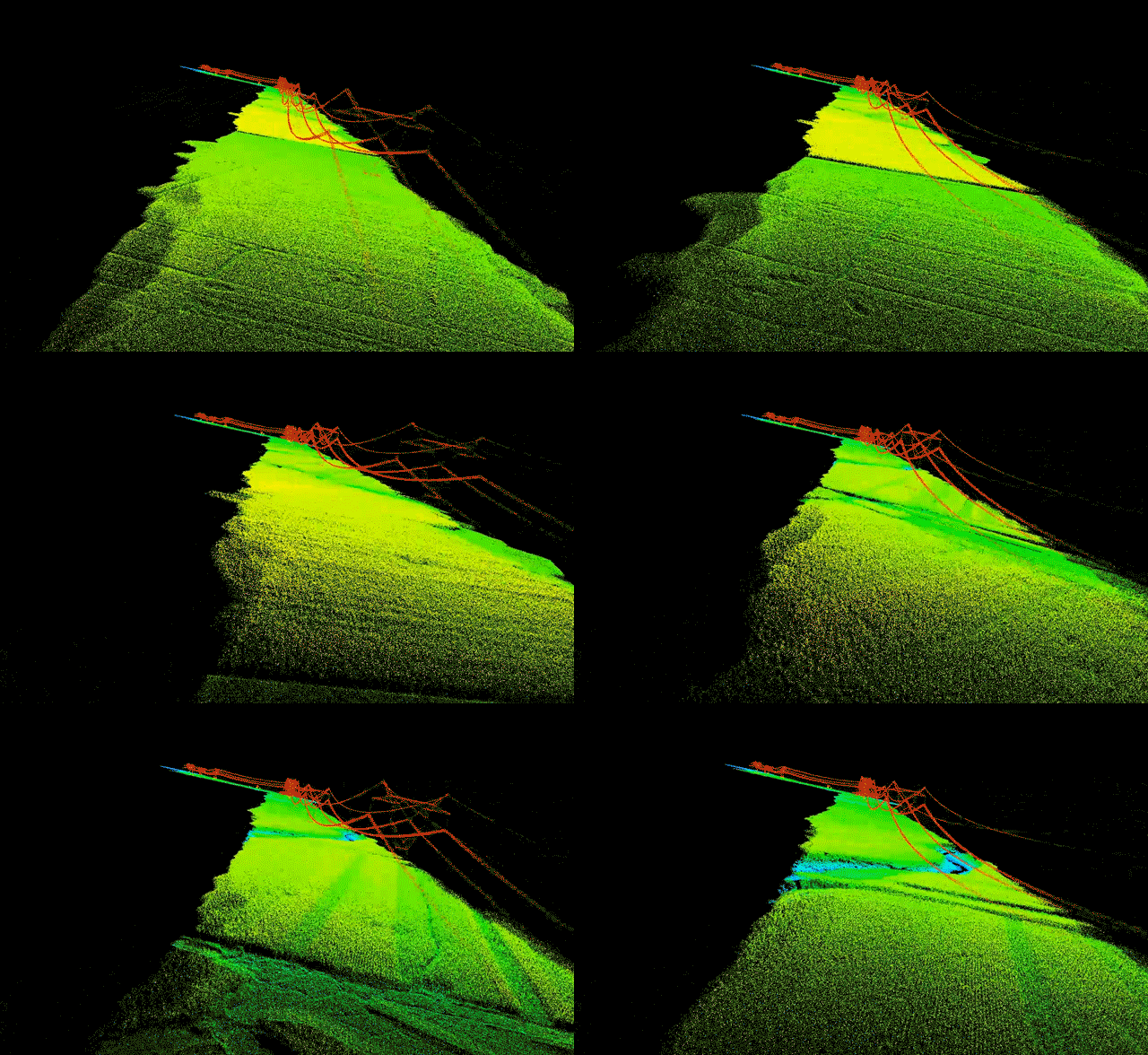
LiDAR can create a three-dimensional point cloud of the corridor, allowing analysts to model terrain, vegetation, towers, and conductors. When repeat surveys use compatible routes and processing methods, the data can also support change analysis.
Possible outputs include:
Classified point clouds.
Digital terrain models.
Digital surface models.
Conductor-to-vegetation clearance measurements.
Vegetation-risk zones.
Maintenance priority maps.
LiDAR accuracy depends on the sensor, flight altitude, scan geometry, GNSS or inertial performance, vegetation density, point-cloud processing, and quality-control method.
Storm, Wildfire, and Emergency Assessment
After storms, floods, landslides, earthquakes, or wildfires, roads may be blocked and ground access may be unsafe.
A long range surveillance UAV can launch from a safe staging area and inspect affected corridors before field crews enter damaged locations.
Emergency missions may support:
Locating damaged towers and conductors.
Identifying fallen trees or debris.
Mapping fire or flood impact near transmission assets.
Checking access routes.
Providing current imagery to emergency teams.
Prioritizing repair and restoration work.
Because emergency routes may differ from routine inspections, planners must recalculate endurance, communication coverage, weather exposure, alternate landing locations, and reserve requirements before launch.
Selecting Payloads for Power Line Inspection
The correct payload should be selected from the required inspection result rather than from the highest available specification.
BOXIANG currently lists EO, EO/IR, tri-sensor, mapping-camera, and LiDAR payload options. The published payload configurations include visible-light cameras, thermal imaging, laser ranging, full-frame mapping cameras, oblique cameras, and LiDAR systems. Payload compatibility varies by aircraft model and configuration. Power Line Inspection Workflow
Step 1: Define the Corridor and Inspection Objective
Begin by defining what the mission must accomplish.
Examples include:
Routine visual inspection of every tower.
Thermal inspection of selected components.
Vegetation-clearance analysis.
Storm-damage assessment.
Construction monitoring.
Mapping of new transmission routes.
The objective determines the payload, flight altitude, viewing angle, route spacing, speed, data volume, and processing requirements.
Step 2: Divide the Corridor into Operational Segments
Long transmission routes should be divided into manageable mission segments.
Segment planning should consider:
Aircraft endurance with the real payload.
Required energy reserve.
Terrain elevation.
Population and ground-risk conditions.
Airspace restrictions.
Communication coverage.
Launch and recovery locations.
Alternate landing sites.
Locations requiring slower flight or additional imaging.
The longest theoretical route is not necessarily the safest or most productive mission. A shorter route with sufficient reserve and reliable data collection may deliver better operational results.
Step 3: Verify Launch and Recovery Sites
Vertical takeoff reduces runway requirements, but the site must still be assessed.
Operators should confirm:
Clear vertical and lateral space.
Surface condition.
Nearby structures and conductors.
Electromagnetic environment.
Wind direction and turbulence.
Personnel separation.
Vehicle and equipment access.
Emergency landing options.
Substations and transmission infrastructure may create navigation, magnetic, communication, or turbulence challenges. Site-specific testing remains necessary.
Step 4: Design the Communication Architecture
BVLOS operation requires reliable command, telemetry, and payload-data planning.
Utilities should separately evaluate:
Command-and-control link.
Telemetry bandwidth.
Live-video requirements.
Payload data-link range.
Cellular, RF, satellite, or relay options.
Terrain shielding.
Link redundancy.
Lost-link procedures.
Data recording when live transmission is interrupted.
For mountainous or forested corridors, the direct distance between the control station and aircraft may not accurately represent real link performance.
Step 5: Establish Flight and Emergency Procedures
The operating procedure should define what happens during normal flight and abnormal conditions.
Important procedures include:
Preflight aircraft and payload inspection.
Route and geofence verification.
Battery or fuel calculation.
VTOL takeoff monitoring.
Transition monitoring.
In-flight communication checks.
Response to deteriorating weather.
GNSS anomaly response.
Lost-link action.
Low-energy action.
Alternate landing.
Post-flight inspection and data verification.
BVLOS approval requirements differ by country and operating environment. Operators should work within the applicable aviation, privacy, critical-infrastructure, and data-security rules.
Measuring Real Mission Endurance
Maximum or unladen endurance should not be used as the only planning value.
Real endurance may be affected by:
Payload weight.
Payload power consumption.
Aerodynamic drag.
Wind direction and speed.
Flight altitude.
Temperature.
Route elevation.
Cruise speed.
Loiter or hover time.
Repeated transitions.
Required reserve.
BOXIANG’s current electric fixed-wing VTOL product table lists payload capacities from 1 kg to 10 kg across the TW08 Mini, TW08 Pro, TW12, TW25, and TW50 electric models. Published unladen endurance ranges from approximately 2 hours 10 minutes to 6.5 hours, while endurance with a listed observation payload is lower. er or heavier missions, BOXIANG’s hybrid product page lists the TW50 and TW120 configurations with payload capacities of 10 kg and 30 kg, and published endurance of 8 and 12 hours with the stated P3-Q40T payload. These figures should still be verified against the final aircraft, payload, fuel, weather, altitude, and reserve configuration. Flight Data to Grid Asset Decisions
Collecting imagery is only the first part of the inspection process.
A useful power-grid workflow should connect aerial data to the utility’s existing asset and maintenance systems.
Organize Data by Asset
Each observation should be linked to the correct tower, span, component, or corridor section.
Useful fields may include:
Asset ID.
Coordinates.
Date and time.
Payload type.
Viewing direction.
Inspection category.
Suspected anomaly.
Review status.
Recommended follow-up.
Previous inspection reference.
Apply Quality Control
Before the field team leaves the operating area, verify:
Corridor coverage.
Image sharpness.
Exposure.
Thermal-data completeness.
LiDAR point density.
Positioning status.
Correct timestamps.
Missing structures or route sections.
Flight and system logs.
Early verification reduces the risk of discovering incomplete data after personnel and equipment have already left the site.
Integrate with GIS and Asset-Management Systems
Inspection data may be delivered through:
GIS map layers.
Asset-linked image records.
Orthomosaics.
LiDAR point clouds.
Thermal anomaly reports.
Maintenance priority lists.
Work-order attachments.
Change-detection dashboards.
The most useful deliverable is not always the largest dataset. Field and maintenance teams often need a clear list of affected assets, coordinates, evidence, severity, and recommended follow-up action.
Choosing a Long Range Surveillance UAV for Power Grid Work
Before purchasing or configuring a platform, utilities should request mission-specific evidence.
BOXIANG Solutions for Power Line BVLOS Inspection
BOXIANG develops electric and hybrid fixed-wing VTOL UAV platforms for long-endurance inspection, mapping, emergency response, and remote-area operations.
For power-grid projects, the aircraft can be configured with payloads such as:
Stabilized EO cameras.
EO/IR gimbals.
Laser-ranging payloads.
Mapping cameras.
Oblique cameras.
LiDAR systems.
Communication-relay equipment.
Relevant product pages include:
The final configuration should be based on the corridor length, required inspection detail, payload weight, terrain, weather, communication architecture, deployment method, and local operating requirements.
Scaling from a Pilot Corridor to a Regional Program
A utility can reduce implementation risk by expanding in stages.
1. Select a Representative Pilot Route
Choose a corridor that includes realistic terrain, structures, communications, and inspection requirements.
Define measurable success criteria such as:
Required image detail.
Percentage of assets inspected.
Data completeness.
Positioning accuracy.
Mission turnaround time.
Number of repeat flights required.
Integration with existing systems.
2. Validate the Complete Configuration
Test the aircraft with the intended payload, route, communication system, reserve policy, and data-processing workflow.
Do not validate the airframe separately and assume the final payload configuration will produce identical performance.
3. Standardize Procedures
Create repeatable procedures for:
Mission planning.
Site assessment.
Aircraft preparation.
Payload configuration.
Flight operations.
Emergency response.
Data quality control.
Maintenance.
Reporting.
4. Integrate Inspection Results
Connect verified results to GIS, asset-management, work-order, or maintenance-planning systems.
5. Expand by Corridor Type
After the workflow is proven, expand to routes with comparable terrain and operational conditions. More complex environments should be validated separately.
Frequently Asked Questions
What is the difference between flight range and control range?
Flight range describes how far the aircraft can travel based on endurance and mission conditions. Control range describes how far the command link can operate under specified conditions. Payload video or data-link range may be different again.
Does every long-range power line mission require BVLOS approval?
Not necessarily. Shorter routes may be conducted under VLOS or other approved operating arrangements. BVLOS requirements depend on the jurisdiction, aircraft, route, airspace, risk assessment, and operating authorization.
Which payload is best for transmission-line inspection?
There is no single best payload. Zoom EO cameras support detailed visual inspection, EO/IR systems add thermal observations, LiDAR supports vegetation and clearance analysis, and mapping cameras support corridor documentation and post-event models.
Can one flight collect both visual and thermal data?
Yes, when the selected aircraft and multi-sensor payload support both functions. The mission must still provide appropriate observation distance, viewing angle, speed, thermal conditions, storage, and data-link capacity.
Is maximum endurance the most important specification?
No. Usable endurance with the actual payload, required reserve, wind, altitude, route, communication coverage, and inspection speed is more important than an unladen maximum.
Can UAV inspection replace all ground and helicopter inspections?
Usually not. UAVs can reduce unnecessary exposure and help prioritize field work, but some defects still require close physical inspection, testing, maintenance access, or verification by qualified personnel.
How can UAV data be integrated into a utility asset-management system?
Images, thermal observations, point clouds, coordinates, and anomaly records can be linked to existing asset IDs and imported into GIS, maintenance, or work-order systems. The file structure and required metadata should be defined before flight.
Conclusion
A long range surveillance UAV can support safer and more repeatable power line inspection by combining extended corridor coverage, runway-free deployment, modular payloads, and structured data collection.
The most effective system is not simply the aircraft with the longest advertised endurance. It is the configuration that delivers the required inspection detail, maintains reliable communication, preserves sufficient reserve, handles the real terrain and weather, and transfers verified results into the utility’s maintenance workflow.
By starting with a representative pilot corridor, validating the complete aircraft-and-payload configuration, and standardizing the data process, utilities can develop a scalable BVLOS power line inspection program for routine patrols, vegetation analysis, thermal inspection, and emergency assessment.
Discuss Your Power Grid Inspection Mission
Provide the corridor length, terrain, required payload, target inspection distance, data output, weather conditions, communication requirements, and deployment constraints.
BOXIANG can recommend an electric or hybrid fixed-wing VTOL configuration for your power line inspection mission.