
VTOL UAV in Smart Cities: Enabling Smarter Infrastructure Monitoring
Smart cities require not only more data but also faster and more reliable ways to collect information across large-scale infrastructure such as utility networks, roads, bridges, waterways, and security perimeters. This is where the dual fixed-wing VTOL UAV delivers unmatched value. With long endurance, high stability, and versatile payload capacity, these UAVs transform complex urban conditions into actionable insights for city operators.
Why VTOL UAV is Essential for Smart Cities
Managing assets spread over hundreds of square kilometers demands both endurance and wide coverage. A dual fixed-wing VTOL UAV combines the efficiency of a fixed-wing glider with the flexibility of rotorcraft, offering runway-free takeoffs even in dense urban areas. Once airborne, the UAV achieves efficient cruising speeds, reducing mission swaps, minimizing downtime, and lowering inspection costs. With high wind resistance, operations remain dependable without waiting for ideal weather conditions.
Dual Fixed-Wing VTOL UAV vs. Multirotor and Fixed-Wing Platforms
Traditional UAVs fall into three categories:
Multirotors: agile but limited in range and endurance.
Fixed-wing UAVs: efficient for long-distance flights but require runways.
Dual fixed-wing VTOL UAVs: combining vertical takeoff with fixed-wing cruising.
For smart-city operations, the hybrid design of VTOL UAVs is the most effective solution, especially for carrying heavier sensors and covering long corridors without additional ground support.
Endurance and Payload Capacity
Longer flight times directly reduce the need for multiple truck deployments, frequent battery swaps, and excessive pilot hours. Higher payload options allow operators to carry LiDAR systems, EO/IR dual-sensor packages, and high-resolution optical zoom cameras, enabling comprehensive inspections in a single mission.
Weather Resistance and Reliability
Urban infrastructure monitoring rarely stops for weather. A VTOL UAV engineered for high-wind stability and consistent takeoff/landing ensures predictable schedules and consistent data, even in challenging conditions.
Core Smart-City Applications of VTOL UAV
1. Utility and Infrastructure Inspections
Dual fixed-wing VTOL UAVs equipped with EO/IR cameras can identify hotspots, corrosion, vegetation encroachment, and structural defects. Integrated AI analysis highlights anomalies in near-real time, ensuring faster repairs.
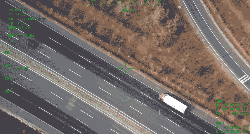
2. Traffic and Roadway Analytics
Using nadir and oblique imaging, VTOL UAVs generate orthomosaic maps for monitoring pavement conditions, potholes, signage, and guardrails. This data is seamlessly integrated into city asset systems, providing a living, time-stamped map of urban infrastructure health.
3. Coastal and Border Security
For coastal cities, VTOL UAVs with long-endurance airframes provide day-night EO/IR surveillance, communications relay, and extended operational range to support ground patrols.
VTOL UAV Data Ecosystem
A UAV is more than an airframe—it is a data ecosystem that integrates sensors, connectivity, GIS, and digital twin platforms.
Sensor Suite: EO/IR, LiDAR, and multispectral cameras.
Connectivity: 5G links and RTK positioning for centimeter-level accuracy.
Data Integration: Seamless incorporation into GIS for creating digital twins of city infrastructure.
This integrated system allows decision-makers to simulate risks, monitor changes, and prioritize budgets with precision.
Why BOXIANG UAV Leads the VTOL UAV Market
CHANG CHUN CHANG GUANG BO XIANG UAV Co., Ltd. (BOXIANG UAV), recognized by Jilin Province as a “Specialized, Refined, Distinctive, and Innovative Enterprise,” brings aerospace-level expertise into smart-city UAV applications. With dual fixed-wing + rotorcraft hybrid designs and proven performance across millions of flight hours, BOXIANG UAV delivers:
Endurance up to 8 hours per flight.
Payload capacity ranging from 1 kg to 50 kg.
RTK positioning accuracy of 1 cm + 1 ppm.
Communication range of 50–100 km.
High wind tolerance up to Beaufort 7–8 conditions.
ROI for Smart Cities with VTOL UAV
City managers adopting VTOL UAVs see measurable improvements:
Reduced truck rolls and lane closures.
Lower inspection costs per kilometer.
Faster detection-to-repair timelines.
Higher data accuracy and frequency.
By centralizing mission planning and enabling multi-department UAV sharing, cities optimize budgets while increasing service efficiency.
Case Studies: Real-World Applications
Roads & Bridges: Detect deck cracks, joint issues, and guardrail damage.
Power & Pipelines: Identify loose hardware, leaks, and vegetation encroachment.
Water & Flood Control: Map levees, embankments, and culverts to assess flood risks.
Public Safety: Support wide-area surveillance and emergency response with EO/IR payloads.
Future Outlook for VTOL UAV in Smart Cities
As urban air mobility evolves, autonomy and AI integration will expand VTOL UAV capabilities. Expect more automated flight planning, sense-and-avoid systems, and seamless U-space/UTM integration, transforming UAVs from inspection tools into mobile, real-time data platforms for smart cities.
Conclusion
Smart cities need more than just drones—they need industrial-grade VTOL UAV systems with long endurance, high payload flexibility, and advanced safety features. BOXIANG UAV’s dual fixed-wing VTOL UAV platforms empower city managers to see further, act faster, and spend smarter—all while building a scalable infrastructure monitoring solution.
FAQs
Q1. How does a VTOL UAV differ from a multicopter?
Multicopters are designed for short, precise missions. A VTOL UAV combines vertical launch with fixed-wing cruising, offering extended range and higher payload capacity.
Q2. What sensors are recommended for utilities?
Start with EO/IR for defect detection, LiDAR for corridor modeling, and multispectral sensors for vegetation analysis.
Q3. How do smart cities ensure data privacy?
By enforcing strict geofences, anonymizing imagery, and limiting data retention with secure access protocols.
Q4. What if weather changes mid-mission?
Choose UAVs with strong wind tolerance and automated return-to-home functions, ensuring operational safety.
Q5. Can one VTOL UAV fleet serve multiple departments?
Yes. Modular payloads and mission flexibility enable one fleet to cover utilities, roads, water management, and public safety, maximizing ROI.