
Modular Payloads on VTOL Fixed Wing: From LiDAR to ISR in Minutes
Why VTOL fixed wing platforms excel with modular payloads
When teams want longer legs without giving up vertical takeoff, they’re after flexibility as much as range. A modular payload strategy on a VTOL fixed wing airframe turns one aircraft into a multi-role tool: LiDAR for mapping at dawn, ISR by noon, infrastructure inspection after lunch—no rewiring, no ground-crew bottlenecks. The payoff is fewer airframes to purchase, simplified training, and a faster path from question to dataset.
The operational gap modularity closes
The old model: carry separate drones for photogrammetry, long-range video, and thermal work—each with its own batteries, spares, and maintenance trail. With a single dual fixed-wing VTOL that accepts hot-swappable payloads, you standardize consumables and cut mission downtime. Procurement and logistics shift from aircraft-centric to mission-centric.
Proof points: endurance, payload, wind
Modularity matters only if the platform can lift real sensors and stay airborne. Our dual fixed-wing VTOL family supports 1–50 kg payload classes and reaches up to 8 hours endurance (unladen). That makes heavy LiDAR scanners or long-range EO/IR gimbals practical, not theoretical. In harsh weather, Level-8 wind capability keeps sorties on schedule when other aircraft stand down.
About CHANG CHUN CHANG GUANG BO XIANG UAV Co., Ltd.
We are CHANG CHUN CHANG GUANG BO XIANG UAV Co., Ltd.—internationally known as Boxiang UAV—a high-tech manufacturer focused on the design, build, and service of intelligent UAVs. Our roots trace to the Chinese Academy of Sciences UAV division (est. 2009). In September 2021 we restructured as an innovation-driven enterprise and were recognized in Jilin Province as a “Specialized, Refined, Distinctive, and Innovative Enterprise,” also serving as a provincial-level national economic mobilization center.
Research DNA, practical advantages
That research heritage shows up in aerodynamic layouts and systems engineering choices: longer endurance at higher payloads than typical hybrid VTOLs and a smaller ground footprint for the same wingspan—useful when you’re staging from tight or contested sites.
Platform fundamentals: airframe, power, and data
Our lift-cruise architecture blends vertical lift rotors with efficient fixed-wing cruise, tied together by redundant power rails and a high-throughput data bus. The airframe is built for plug-and-play payloads—consistent power, time sync, and deterministic comms without custom harnesses for every mission.
VTOL fixed wing architecture & redundancy
Once on the wing, the aircraft sips energy—translating into more sensor-on time. Mission-critical systems (power distribution, flight control, datalinks) are hardened for graceful degradation. Multi-UAV collaboration and resilient relay comms remain viable even under “triple disruption” events (loss of power, signal, and network).
Environmental hardening
Operations rarely enjoy perfect weather. The platform’s wind resilience is designed-in, not bolted on. Level-8 wind performance preserves timelines, and sealed gimbal interfaces reduce moisture ingress during low-visibility launches and recoveries.
Payload ecosystem: LiDAR, EO/IR, multispectral
We cover the big three out of the box:
LiDAR with PPK/RTK alignment for survey-grade point clouds
EO/IR gimbals (4K EO, LWIR, laser range finder ~3000 m) and up to 240× hybrid zoom
Multispectral sensors with edge analytics (NDVI/NDRE, canopy metrics)
LiDAR mapping (topography, utilities, forestry)
Corridor work and canopy modeling demand a steady airspeed envelope and long straight legs. A VTOL fixed wing delivers both. Modern scanners fire hundreds of thousands of pulses per second; combined with endurance, you’ll fly fewer lines with higher overlap—cleaner DEMs and faster deliveries.
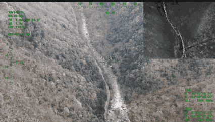
EO/IR for ISR & inspection
ISR needs reach and clarity. A stabilized gimbal with 4K EO, thermal, and LRF extends detection and identification ranges while reducing operator fatigue. With 240× hybrid zoom, maintain safe standoff and still read critical details—without time-consuming repositioning.
Multispectral with analytics at the edge
From crop vigor to post-fire assessment, multispectral payloads convert spectra to decisions. Fly one sortie, compute NDVI/NDRE on-board, and push quick-look results over a secure link before landing—accelerating emergency response and field tasking.
Field workflow: from crate to sky
A quick “LiDAR at sunrise, ISR by noon” swap looks like this:
Roll out airframe and ground case.
Seat the LiDAR via quick-release collar.
Blind-mate the power/data connector—no cable hunt.
Run LiDAR self-check and IMU warm-up.
Launch, fly lines, recover.
Release collar, remove LiDAR, mount EO/IR gimbal.
System auto-detects payload and loads gimbal parameters.
Quick boresight; relaunch for ISR.
Tools required: two hex keys. Downtime: minutes.
Smart mounts, connectors, and balance
Keyed mounts prevent misalignment; captive fasteners stay put; a CG checker in the mission app confirms balance. Because mass and drag shift, the controller adjusts pitch trim and climb rates automatically—keeping handling familiar across missions.
Interfaces that keep options open
Payload bays expose regulated power rails and high-current feeds. For data: Gigabit Ethernet for streaming sensors, CAN/UART for control, and GPS time marks for tight sync with LiDAR/cameras. Integrators add modules without redesigning the aircraft.
Mounting on VTOL fixed wing airframes
From NATO-style rails to circular gimbal rings, we support common patterns. Belly-mount rings protect LiDAR on touchdown; nose- or belly-gimbals give full-hemisphere coverage with minimal fuselage masking. Quick-release plates let you change roles without re-rigging harnesses.
Compliance & safety for BVLOS and critical ops
For beyond visual line of sight, documentation matters. Select models in our family have been publicized with airworthiness approvals (e.g., CAAC for TW-series classes)—helping regulated operators streamline CONOPS and waivers. Redundant power and hardened comms deliver graceful degradation when the unexpected happens.
Reliability by design
Our test matrix covers thermal cycling, vibration, ingress, loss-link behaviors, and return-to-base logic. In multi-UAV modes, relay comms maintain ISR links even when a direct path drops—vital in disaster zones or spectrum-noisy corridors.
Civil and defense use cases
One VTOL fixed wing, many roles:
Utilities: 110 kV corridor scans, substation modeling
Public safety: wildfire reconnaissance, search support
Maritime: littoral patrol, shoreline inspection
Industrial: pipeline, rail, and wind farm inspection
Defense: long-endurance ISR where portability and wind resistance are non-negotiable
Two sample mission loads (LiDAR ↔ ISR)
Load A—LiDAR Survey: Airframe + LiDAR pod + PPK antenna + downlink recorder. Fly 120–150 m AGL at 16–20 m/s with 30–40% overlap for crisp point clouds and minimal shadowing.
Load B—ISR/Inspection: Airframe + EO/IR gimbal (4K/thermal) + LRF. Patrol 250–400 m AGL with orbit holds. Achieve positive ID via high-zoom EO, confirm heat signatures in IR, and range targets to ~3 km.
ROI that shows up on the balance sheet
One airframe, multiple missions means lower capital outlay and standardized maintenance. Modularity cuts idle time, and endurance reduces relaunches. Survey teams get denser point clouds per flight; ISR teams cover more grid squares per shift. You spend hours collecting data—not babysitting gear.
What’s next
Edge AI will fuse LiDAR with EO/IR in real time, flagging anomalies while you’re still airborne. Swarm-ready comms will choreograph multiple aircraft so one maps while another overwatches. Open, documented interfaces will invite third-party payloads without month-long integrations. Our roadmap leans hard into that future.
Why operators choose our VTOL fixed wing platforms
Payload + endurance: plan ambitious sorties without compromise.
Small ground footprint: launch from tight sites others can’t use.
True multi-role: re-role the same airframe all week without racks of adapters.
Spec snapshots that matter to payload teams
Payload/endurance envelope:1–50 kg payload class; up to 8 h unladen endurance.
Wind operations: up to Level-8 conditions.
Comparative advantage: up to 2× endurance and 2× payload vs. typical hybrid VTOLs of similar size; ¼–⅕ ground footprint at equal wingspan.
EO/IR features:4K imaging, ~3000 m laser ranging, 240× hybrid zoom.
Final word
Modularity isn’t a slogan—it’s operational freedom. With a VTOL fixed wing platform built for quick-change payloads, you can fly LiDAR at sunrise, switch to ISR before lunch, and finish the day with actionable maps and confirmed IDs. That’s what CHANG CHUN CHANG GUANG BO XIANG UAV Co., Ltd. builds: less friction, more mission.
FAQs
Q1: How fast is a LiDAR-to-ISR swap?
Most crews finish in minutes thanks to keyed mounts and blind-mate connectors. A short boresight and you’re airborne.
Q2: What interfaces do the payload bays support?
High-current rails, regulated auxiliary power, Gigabit Ethernet, CAN/UART control, and GPS time marks for synchronization.
Q3: Can the same aircraft handle windy coastal missions?
Yes. Level-8 wind capability keeps flights viable when conditions turn rough.
Q4: Do you support BVLOS operations?
Select models have documented airworthiness approvals (e.g., CAAC for TW-series classes), aiding regulated BVLOS workflows.
Q5: What sensors are available off the shelf?
LiDAR pods, EO/IR gimbals (4K + thermal), multispectral cameras, and laser range finders up to ~3000 m.