
UAV for Surveillance in Border Operations: Dual-Wing Stability, Long Links, and 24/7 EO/IR Patrols
Borders are rarely “one place.” They’re long, messy, and constantly changing—mountain ridgelines, rivers, farmland, desert tracks, and the occasional patch of urban fringe. That’s why UAV for surveillance in border operations isn’t about flashy tech. It’s about repeatable coverage, stable imagery, and a link you can trust when the terrain stops being friendly.
At CHANG CHUN CHANG GUANG BO XIANG UAV Co., Ltd. (BOXIANG / BXUAV), we build dual fixed-wing VTOL UAVs for exactly this kind of mission: launch from improvised sites, cruise efficiently for long corridors, carry serious EO/IR payloads, and keep operations running day and night.
Why Border UAV Surveillance Is a Different Kind of Hard
Border patrol has three non-negotiables:
Coverage — long routes, predictable patrol patterns, and the ability to scale beyond “a circle around the takeoff point.”
Continuity — gaps are where trouble hides.
Credible imagery — shaky or low-confidence video isn’t just annoying; it can derail decisions.
And unlike controlled test ranges, border environments bring real-world constraints: limited launch infrastructure, gusty ridge winds, temperature swings, and signal shadowing.
The “Long Fence, Small Team” Problem (and Why VTOL Fixed-Wing Helps)
Most border teams don’t have unlimited operators, vehicles, batteries, or daylight. The real goal is simple:
Cover more kilometers with fewer launches.
That’s where a VTOL fixed-wing UAV shines:
VTOL removes runway dependence—launch from a compact clearing, roadside flat spot, or small staging point.
Fixed-wing cruise delivers efficient long legs for wide-area patrols.
A pure multirotor can hover, sure—but it burns energy like a sprint. A conventional fixed-wing can cruise—but often demands launch/recovery infrastructure. Border work usually needs both.
Why Dual-Wing + Full-Vector Control Shows Up in the Footage
Here’s a truth operators learn fast: If the airframe is fighting the wind, your camera fights it too.
BOXIANG’s dual-wing VTOL architecture combines:
Dual-wing + multi-rotor aerodynamic layout
Full-vector control
Wind-adaptive stability response
The goal isn’t just “survive wind.” It’s keep the platform calm enough that EO/IR video stays usable when the weather turns rude.
Wind and Environment Specs That Matter for Border Work
From our published platform specs across the series:
Wind resistance: up to Beaufort Level 8 in cruise/level flight (model/phase dependent)
Operating temperature:−20°C to +65°C
Service ceiling: up to 5,500 m
GNSS: GPS + GLONASS + BeiDou + Galileo
System self-check:≤ 2 minutes
Operational: under light rain conditions
When your patrol schedule is 24/7, those “boring” numbers are what keep sorties from getting canceled.
Long Links for Long Routes (Range Isn’t Just Flight Time)
For a UAV for surveillance, “range” is two things:
How far you can fly
How reliably you can send data back
For corridor patrols, you care about link margin along a rectangle, not best-case distance in perfect conditions.
BOXIANG’s fixed-wing VTOL UAV series supports 50–100 km communication/control range on larger configurations (model/config dependent). For compact platforms, control/comm ranges can be shorter (e.g., 15 km / 35 km on smaller units), which is why we help teams match airframe size to the corridor they actually need to cover.
A Practical Dual Fixed-Wing VTOL Lineup for Surveillance Missions
Border work is not one-size-fits-all. Sometimes you need a portable unit for quick redeployment. Sometimes you need endurance and heavier payload capacity for long corridors.
From our published series table (electric models), examples include:
TW50 (Electrical)
Max payload: 10 kg
Endurance:6.5 h (unladen); about 5 h with P1-120x payload
Cruise speed:65–90 km/h
Control/comm range options:50 / 70 / 100 km (config dependent)
TW200 (Electrical)
Max payload: 50 kg
Endurance:8 h (unladen); about 7.5 h with P1-120x payload
Cruise speed:65–90 km/h
Control/comm range options:50 / 70 / 100 km (config dependent)
If your concept of operations requires fewer launches to maintain continuity, these endurance bands change staffing, vehicle movements, and operator fatigue in a very real way.
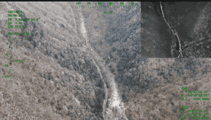
24/7 Border Patrol Means EO/IR Flexibility (Not Just “A Camera”)
Border surveillance is basically a three-step loop:
Detect something unusual
Identify what it is
Track it long enough to decide what to do
You can sometimes detect with “okay” video. But you can’t identify and track reliably—especially at night—without the right payload.
BOXIANG EO/IR Payload Options We Publish (Examples)
240× series (4K / 8.51 MP visible):
P1-240x (Visible): 8.51 MP, 4K (3840×2160), 20× optical, 240× hybrid
P2-240x (Visible + IR): adds 640×512 thermal
P3-240x (Visible + IR + Laser): adds laser ranging 50–3000 m
120× series (5.13 MP visible):
P1-120x (Visible): 5.13 MP, 10× optical, 120× hybrid
P2-120x (Visible + IR): adds 640×512 thermal
P3-120x (Visible + IR + Laser): laser ranging 5–1500 m
For border operations, the “why” is straightforward:
Day: wide scan → zoom to confirm → track with context
Night: thermal detection → verify with EO where possible → range for clean handoff
Why Laser Ranging Changes Handoffs
Without ranging, “it’s over there” is vague. With ranging, teams can pass more confident target positioning—especially when coordinating patrol units, fixed cameras, or response teams that need actionable distance calls.
Ground Control That’s Built for Operators (Not Just Engineers)
In real patrol work, operators need fast planning, clear telemetry, and minimal pre-flight friction.
Our ground control station software supports:
flight route planning
one-click takeoff
autonomous cruising
real-time display of altitude, wind speed, battery level, signal strength, mission map, and live video transmission
We also publish multiple ground station form factors, including portable options. For example, the portable large-screen ground station lists sunlight-readable screens (e.g., 1000 NIT brightness) with 10.1-inch or 13.3-inch dual-screen configurations, and published image transmission specs such as 30 km or 50 km (device dependent).
A Simple, Repeatable Border Surveillance Workflow
Step 1: Plan the patrol like a schedule, not a demo
Use consistent altitudes, predictable turn points, and defined comm checkpoints so anomalies stand out.
Step 2: Launch from “whatever you’ve got”
VTOL removes runway dependence, which keeps you flexible when terrain and access points change.
Step 3: Scan wide, then zoom smart
Don’t spend the whole flight staring through a soda-straw view. Scan, detect, then zoom to identify.
Step 4: Track, tag, and hand off
Stable imagery plus ranging (when configured) makes handoffs cleaner and faster.
Step 5: Recover safely—even when things go sideways
For border operations, you don’t plan to lose a link—but you absolutely plan for it. Our published safety features include GNSS anomaly handling, automatic return-to-home on signal loss, and low-battery alerts with autonomous return behaviors.
Why BOXIANG Builds for Border Surveillance Programs (Not One-Off Flights)
Border surveillance rewards systems that behave like a reliable teammate: predictable, steady, and ready when the schedule says “go.”
BOXIANG’s published company and platform background includes:
roots in the UAV Division of the Chinese Academy of Sciences (2009) and restructuring into an innovation-driven enterprise (September 2021)
80+ core patents / proprietary technologies
an 8,000+ m² R&D and production facility with dedicated flight testing airspace
quality certifications listed such as GB/T19001-2016 / ISO9001:2015 and service certifications
And for teams that need stronger regulatory confidence, we’ve also published that TW50 and TW200 achieved CAAC Special Airworthiness Certification with zero corrections, with mission notes including EO/IR support for long-range patrols and 24/7 border surveillance, plus options like self-organizing network links or satellite communication links (model/config dependent).
FAQs
1) What’s the biggest advantage of VTOL for border patrol teams?
Flexibility. VTOL eliminates runway dependence, so you can launch and recover from tight field sites when geography doesn’t cooperate.
2) Is a UAV for surveillance more about the airframe or the payload?
Both. The airframe gives you stability, endurance, and wind handling. The payload decides whether you can identify and track—especially at night with thermal and ranging.
3) What kind of comms range supports corridor patrols?
For longer corridors, you typically look for systems supporting 50–100 km control/communications (model/config dependent), plus good corridor planning (line-of-sight, link margin, failover rules).
4) What helps reduce mission disruption in harsh conditions?
Wind-stable flight behavior, fast pre-flight workflows (e.g., ≤2 min self-check), and safety functions like GNSS anomaly handling and automatic RTH.
5) How do you structure 24/7 coverage realistically?
Treat it like shifts: standardized route templates, planned overlaps, and tight turnaround (fast checks, fast swaps). Higher endurance reduces launches and operator fatigue.