
Dual Fixed-Wing VTOL Edge: Your Most Enduring Surveillance UAV for Sale
Looking for a surveillance UAV for sale that doesn’t force you to choose between VTOL convenience and fixed-wing range? Our dual fixed-wing VTOL platform gives you both: runway-free launch/landing and efficient wing-borne cruise that keeps you on station far longer than typical multirotors. That mix—anywhere access plus real endurance—is why utilities, public safety teams, and defense users deploy it for persistent ISR.
Why Dual Fixed-Wing VTOL Changes the Surveillance Equation
Two wings share the lift and stabilize the airframe. In the air, that means smoother video in gusts, room for heavier gimbals, and easier balancing of payloads. VTOL rotors handle takeoff and landing, so you’re never hunting for a runway or flirting with stall margins on approach. The result: a high-endurance imaging platform that slots into the same team workflow as a multirotor—just with miles more reach.
Operational flow in the field
Stage from a small clearing or pier
Lift vertically via rotors, then transition to efficient wing flight
Loiter for extended periods without swapping batteries
Recover vertically in tight spaces, even with obstacles around
Endurance: The Decisive ISR Metric
Endurance isn’t a line on a spec sheet—it’s a force multiplier. More minutes aloft means:
More ground covered per sortie
Higher chance to reacquire a moving target
Fewer risky, time-burning battery swaps
Less disruption to emergency crews and subjects on scene
Longer time on wing also gives analysts cleaner, continuous datasets—fewer gaps, fewer blind spots, better decisions.
From Flight Time to Mission Outcomes
Coastline patrol: Longer loiter improves the odds of spotting fast skiffs between radar sweeps—without crowding the target.
Post-storm powerlines: Finish a full segment in one pass. Consistent point density means faster, more reliable clearance checks.
Wildfire overwatch: Orbit for hours, map heat signatures, and guide crews as conditions shift.
How to Choose a Surveillance UAV for Sale—Without Guesswork
Start with the mission, not the brochure:
Environment: terrain, wind profile, launch/landing constraints
Dwell time: how long you must hold a target or corridor
Deliverables: positive ID, thermal mapping, 3D modeling, or vegetation metrics
Payloads: EO/IR for day/night ID; LiDAR for structure; multispectral for crop/vegetation health
Our payload library is built for this mix—from long-zoom EO/IR to LiDAR and multispectral kits—so you match sensors to outcomes instead of compromising.
Catalog vs. Custom: Which Path Fits?
Catalog platform: ships faster, validated airframe-firmware-payload stack, easier to support at scale (ideal for repeatable missions like borders and utility corridors).
Custom build: right for niche sensors or extreme environments when your requirements fall outside standard envelopes.
Payload Pairing That Works
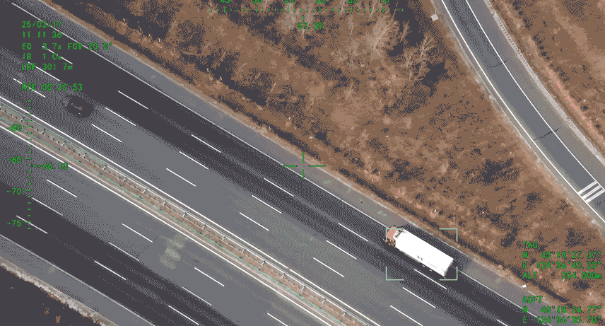
EO/IR gimbals: UHD imaging with up to 240× hybrid zoom for stand-off identification.
Laser rangefinder: precise ranging up to ~3,000 m, confirming distance so you can identify without flying too close.
LiDAR: high-fidelity 3D modeling where line-of-sight imaging falls short.
Multispectral: crop stress, post-fire recovery, and vegetation encroachment analysis.
Modularity matters: hot-swap sensors to pivot from night overwatch to corridor mapping in minutes.
The Airframe Advantage
Dual wings distribute lift to reduce wing loading and steady the picture. That stability buys you payload headroom: heavier, longer-range gimbals without turning every gust into a shaky frame. We engineer for repeated VTOL cycles, rough-ground launches, and fast turnarounds—day after day.
Design considerations that pay off
Balanced wing loading for slow-flight imaging
Prop/ESC choices that reduce noise for discreet operations
Rugged structure for field abuse and quick serviceability
Command, Control, and Autonomy—At Scale
A surveillance aircraft lives or dies by its C2 link and ground software. Our flight software supports:
Route planning and one-click launch
Autonomous cruise and transition
Live telemetry overlays (altitude, wind, battery, signal)
Mission map with live video, gimbal control, and quick reroute tools
When conditions change—a wind shift or a new cue—you can drag a loiter, retask the gimbal, and confirm link margins without digging through menus.
Safety Engineering & Certifications
Regulators trust proof over promises. We have publicized CAAC special airworthiness approvals for TW-series classes (e.g., TW50, TW200) along with high-altitude verification and multi-sensor integration records. For buyers in regulated environments, third-party review accelerates deployment and simplifies internal risk sign-off.
Your checklist: look for type/special airworthiness acknowledgments, EMC results, and documented payload integration test reports—especially for BVLOS or heavier gimbals.
Where This Platform Shines
Utility corridors: powerlines, pipelines, water conservancy
Borders & coastal: long-leg patrol with stand-off EO/IR ID
Emergency response: IR for hotspots, RGB for ortho-mosaics, optional radio relay for patchy comms
Forestry & security: wide-area coverage with runway-free ops
Sensor playbooks by mission
Utilities: LiDAR + RGB for 3D line modeling and vegetation encroachment
Borders/coastal: EO/IR with long zoom for positive ID at range
Emergencies: IR + RGB, optional relay to keep comms flowing
Who We Are
CHANG CHUN CHANG GUANG BO XIANG UAV Co., Ltd. is a high-tech manufacturer focused on R&D, production, sales, and service of intelligent UAVs. Recognized as a “Specialized, Refined, Distinctive, and Innovative Enterprise” in Jilin Province, we also serve as a provincial-level national economic mobilization center. Our roots trace to 2009 within the Chinese Academy of Sciences; we restructured into an innovation-driven company in September 2021.
What that means for you
8,000+ m² R&D and production facility
Dedicated flight-test airspace for rapid iteration
In-house aero structures, payload benches, and repeatable test corridors
Products that ship with the “little things” sorted—mounting, balance, firmware, documentation
Field-Tested Vignettes
Coast guard watch: Launch from a pier, transition to wing, ride the shoreline. IR tags heat near an inlet; EO confirms hull markings from stand-off. No boat ramp, no runway—just results.
Wildfire overwatch: Narrow service road launch, two-hour orbit over a ridge, thermal map guides crews and airtankers as winds shift.
Powerline 3D models: After storms, LiDAR + RGB captures sag, clearances, and tower deformation in one sortie. Fewer landings, consistent point density, faster clearance review.
Pricing the Right Way: Total Cost of Ownership
Price tags don’t tell the whole story. Consider:
Training: intuitive GCS lowers time to proficiency
Maintenance: VTOL cycles demand robust frames and easy service
Batteries: plan around cycle life and charging logistics; endurance reduces pack counts
Software: route planning, telemetry, and video pipelines need regular updates—budget for it
Support & spares: SLA terms, turnaround times, and documentation matter
A validated platform with documented payload integrations and certifications shortens time-to-mission and cuts the “integration tax.”
Buyer’s Checklist for Any Surveillance UAV for Sale
Endurance on wing: verified times with your payload
Payload fit: EO/IR zoom specs, laser range limits, LiDAR/multispectral compatibility; ask for sample datasets
Wind handling: flight logs and stabilization footage from gusty days
GCS & autonomy: route planning, one-click launch, live overlays; test the UI yourself
Certifications & testing: airworthiness acknowledgments, high-altitude verifications, payload integration reports
Support & spares: SLA, lead times, documentation, and training seats
TCO model: batteries, maintenance, software renewals, accessories
FAQs
Q1: How is a dual fixed-wing VTOL different from a tilt-rotor?
A tilt-rotor pivots propellers. A dual fixed-wing VTOL separates vertical lift (rotors) from wing-borne cruise. That separation simplifies transitions and broadens payload options.
Q2: What sensors are typical for corridor patrols?
EO/IR for day/night ID, plus LiDAR for 3D structure (e.g., powerlines). Our payload lineup includes UHD imaging, large zoom ranges, and long-range laser ranging.
Q3: Can I operate in strong winds?
Dual wings improve stability and payload headroom. Ask for wind-day flight logs and sample footage; we can provide both.
Q4: What certifications should I ask about?
Relevant airworthiness or special approvals, EMC results, and sensor integration reports. We have publicized CAAC special approvals on TW-series models (TW50, TW200).
Q5: How do I choose EO/IR zoom levels?
Work backward from target size and standoff distance. Higher hybrid zoom plus a laser rangefinder (up to ~3,000 m on listed payloads) lets you confirm ID without flying dangerously close.
Conclusion
If surveillance is the mission, endurance is the advantage. A dual fixed-wing VTOL gives you runway-free access and true fixed-wing legs in a single airframe—exactly what you need for wide-area monitoring, night ID, or disaster mapping.
At CHANG CHUN CHANG GUANG BO XIANG UAV Co., Ltd., we build for that reality: long time on wing, validated payloads, operator-first software, and a certification mindset.
Evaluating a surveillance UAV for sale? Ask for real flight data, sample datasets, and documented testing. Choose the platform that stays in the air—and keeps delivering answers—long after others have landed.