
Managing water infrastructure is fundamentally a challenge of geography. Hydroelectric dams sit anchored in steep mountain valleys, while river basins run across hundreds of miles of wetlands, farmlands, and rocky corridors. Keeping these facilities safe and monitoring these waterways has traditionally demanded manual field labor: dispatching teams along access roads, scaling concrete spillways, or manually launching handheld drones.
The introduction of industrial-grade drone-in-a-box systems fundamentally changes that workflow. By placing self-charging, weather-sealed base stations directly at critical hydrological points, water conservancy authorities can replace irregular manual site visits with automated, repeatable aerial monitoring.
The Operational Bottlenecks of Traditional Dam and Waterway Inspection
Water assets undergo relentless wear. Concrete faces
degrade under freeze-thaw cycles, earthen embankments face sub-surface erosion, and spillways handle massive hydraulic forces during seasonal storms. At the same time, regional river networks require persistent oversight to catch unpermitted sand excavation, enforce environmental buffers, and manage flood risks.
Safety hazards and physical blind spots: Inspecting a tall arch dam with rope access or scaffolding is dangerous. Ropes leave blind spots along vertical faces, and water-level inspections from boats fail to capture clear angles inside spillway bays.
Low inspection frequency: Because manual surveys require extensive planning and favorable weather, many dams and levees receive comprehensive checks only once or twice a year. Sub-surface piping or joint displacement can develop unnoticed between those intervals.
The field-dispatch bottleneck: Early drone deployments helped remove people from ropes, but they still required certified pilots in the field. When torrential rains arrive—the exact window when dam spillways and reservoir levels must be monitored—washed-out mountain roads often keep field teams from reaching the launch site.
Inside an Autonomous Drone Dock for Water Conservancy
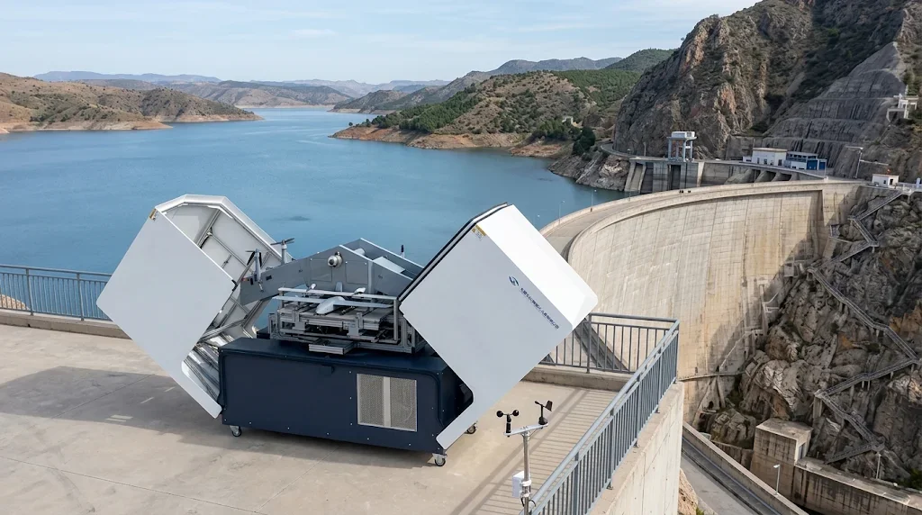
An industrial Drone Dock for Water Conservancy serves as an unmanned hangar and maintenance bay permanently installed on a dam crest, pump station, or riverbank. Operating through centralized cloud management software, it manages the complete flight lifecycle without human presence on site.
Environmental clearance: Onboard sensors measure wind speed, rainfall, barometric pressure, and ambient temperature to verify whether conditions fall within safe operating envelopes.
Automated deployment: Motorized hatch doors open, the internal elevator lifts the drone to the launch deck, and the aircraft aligns its dual-antenna RTK positioning.
Mission execution: The drone flies pre-programmed 3D waypoints at fixed offsets from the dam face or follows linear river corridors.
Precision recovery and fast charging: The drone touches down on the landing deck with centimeter accuracy. The enclosure closes, active heating or cooling stabilizes battery temperatures, and conductive contacts recharge the aircraft for the next sortie.
Data synchronization: High-resolution optical, thermal, or LiDAR data uploads via fiber, 5G, or microwave link to regional servers for automated photogrammetric stitching and anomaly detection.
Airframe Selection: Fixed-Wing VTOL vs. Multirotor Platforms
Choosing the right aircraft architecture dictates the operational reach of any docking installation. Standard multirotors work well for vertical, localized structures, but linear water management across expansive basins requires wing-borne lift.
Deploying fixed-wing VTOL water resource inspection platforms gives operators vertical takeoff capability inside tight mountain cuts without needing a paved runway. Once clear of tree lines and canyon walls, the craft transitions into forward cruising flight. This allows a single dock to patrol an entire reservoir rim or a long stretch of river that would otherwise require multiple multirotor stations.
Operating BVLOS Drone Water Management Solutions
To cover real-world watersheds, docks must run beyond visual line of sight. Traditional visual-line-of-sight rules require spotters to keep eyes on the aircraft, eliminating the labor savings of automation. Modern BVLOS drone water management solutions rely on connected infrastructure to operate safely across long distances:
Dual-path communications: Aircraft maintain telemetry through private 4G/5G cellular bands supplemented by long-range line-of-sight microwave data links or low-latency satellite fallback.
Onboard terrain follow: When flying through winding river valleys, aircraft pull from high-resolution digital elevation models to maintain uniform altitude above water level, avoiding sudden terrain rises and power line crossings.
Multi-dock leapfrog routing: Along extended waterways, docks can be networked together. A drone departs from Base A, inspects 40 kilometers of river embankment, lands at Base B to recharge, and continues along the basin.
Structural Health: The Automated Dam Inspection Drone
Concrete and embankment dams require precise measurement over time. A single snapshot has limited value; the real engineering insight comes from tracking minute structural movements across months and years.
Millimeter Crack Detection on Concrete Faces
Because an Automated Dam Inspection Drone flies identical, automated paths relative to the structure, every photo matches historical coordinates. Computer vision models compare these sequences pixel by pixel, filtering out normal water discoloration to flag true structural defects:
Transverse and longitudinal cracks down to sub-millimeter widths
Joint separation along spillway blocks and crest slabs
Spalling, exposed rebar, and surface efflorescence caused by chemical leaching
Thermal and LiDAR Analysis for Sub-Surface Anomalies
Internal water infiltration rarely shows up on visible cameras until damage is advanced. Radiometric thermal sensors identify subtle temperature variations on the downstream face of embankment dams, where escaping reservoir water cools or warms the surrounding rock.
Paired with LiDAR, the aircraft captures dense ground points through dense vegetation along abutments. These scans produce bare-earth elevation profiles that alert engineers to localized slope slippage, settlement depressions, or piping collapses well before a routine field patrol would spot them.
Basin Protection via an Autonomous Drone Dock for River Patrol
Water security covers more than the dam structure itself. Silt buildup, illegal encroachments, and unpermitted discharges affect downstream water quality and flood capacity.
Dredging and unpermitted works: Running scheduled sorties from an autonomous drone dock for river patrol provides continuous visual coverage over active riverbeds. Onboard edge computing spots commercial excavators, dredgers, and unpermitted drainage outlets, generating geotagged alerts for regional water boards.
Bank erosion mapping: Periodic aerial photogrammetry measures volume loss along vulnerable river bends. Tracking bank retreat helps flood control districts prioritize stone riprap reinforcement where levees face the highest scouring.
Debris and water hyacinth tracking: Large rafts of floating debris and invasive weeds can block intake trash racks and choke spillway gates. Automated runs measure the drift speed and footprint of floating debris fields during high-flow seasons.
Automated Flood Monitoring Drone System for Crisis Operations
During extreme rainfall, response speed matters. River levels surge within hours, and access roads to critical sluice gates frequently wash out. An automated flood monitoring drone system provides uninterrupted operational oversight when conditions prevent human teams from entering the field.
Immediate mobilization: Docks open within 60 seconds of a dispatch command, giving incident commanders immediate video feeds of reservoir backwaters, inflow levels, and levee conditions.
Spillway discharge monitoring: Aerial video monitors high-velocity water discharge over spillway flip buckets, helping operators observe hydraulic jump behavior and scour development in the plunge pool.
Rapid inundation assessment: Automated orthomosaics quickly map flooded agricultural tracts, breached dykes, and severed road corridors, giving first responders reliable spatial data to plan evacuation routes.
Data Integration: Smarter Reservoir UAV Patrol
Data collected during a routine Reservoir UAV Patrol integrates directly with wider asset management software. Aerial point clouds, elevation models, and radiometric rasters connect to existing SCADA and GIS networks.
Engineers can overlay drone telemetry with structural sensor data—such as piezometer pressure levels, joint meters, and internal pendulum readings—inside a centralized digital twin. If an internal piezometer shows a pressure spike, the control room can trigger an automated drone mission to inspect that exact coordinate on the downstream face, confirming or ruling out visible surface anomalies within minutes.
Industrial Engineering: CHANG CHUN CHANG GUANG BO XIANG UAV Co., Ltd.
Deploying unmanned systems in alpine river valleys requires robust, industrial hardware. Consumer airframes lack the structural stiffness, wind margins, and environmental sealing demanded by continuous conservancy operations. CHANG CHUN CHANG GUANG BO XIANG UAV Co., Ltd. engineers flight platforms designed specifically for these conditions.
Research foundations: The company traces its technical heritage to the UAV Division of the Chinese Academy of Sciences in 2009. In September 2021, the team restructured into an innovation-driven enterprise focused on the research, manufacturing, and full-lifecycle service of industrial UAVs.
Recognized engineering credentials: Designated as a "Specialized, Refined, Distinctive, and Innovative Enterprise" in Jilin Province, the company also operates as a provincial-level national economic mobilization center.
Manufacturing and testing capacity: Operating from an 8,000+ square meter research, development, and production center with dedicated testing airspace, the company manufactures specialized dual fixed-wing VTOL systems.
Airworthiness standards: Our platforms have earned Special Airworthiness Certification from the Civil Aviation Administration of China (CAAC) with zero corrections, reflecting strict production discipline, aerodynamic stability, and system redundancy.
Paired with all-weather automated ground docks, our dual fixed-wing VTOL aircraft provide the endurance, payload stability, and structural reliability needed to manage dams, reservoirs, and river corridors in demanding environments.
Moving Toward Systematic Watershed Automation
Automated drone hangars replace sporadic, labor-heavy surveys with continuous, reliable structural intelligence. Combining sealed base stations, long-range fixed-wing VTOL platforms, and BVLOS networks allows regional authorities to spot micro-fissures early, track riverbank stability, and respond to flood events with minimal delay. Automated infrastructure inspection delivers the clear, repeatable data required to keep major water assets safe for decades to come.
Frequently Asked Questions
How does an autonomous drone dock handle extreme weather?
Docks are built to IP65 or higher environmental ratings. Integrated weather sensors track wind velocity, rain, and temperature in real time. If conditions exceed flight margins, the automated system delays scheduled sorties and alerts remote dispatchers. Internally, integrated HVAC and heating units maintain ideal battery and avionics temperatures, ensuring the aircraft is ready to launch as soon as weather conditions clear.
Why use a fixed-wing VTOL instead of a standard quadcopter for river surveys?
Multirotors burn significant battery power simply staying aloft, which typically caps their endurance at 30 to 45 minutes and limits coverage to a few kilometers. A fixed-wing VTOL takes off vertically without a runway, then cruises on aerodynamic wing lift. This setup yields flight times exceeding 90 to 180 minutes, letting operators patrol dozens of kilometers of riverbanks or reservoir perimeters in a single flight.
Can an automated aerial system detect internal seepage in an earthen dam?
Yes. Radiometric thermal cameras identify subtle surface temperature differences caused by escaping moisture. Water moving through an embankment alters soil surface temperatures compared to dry surrounding sections. By running recurring, calibrated thermal flights, analytics platforms detect seepage pathways long before water emerges as visible pooling.
What communications are required for BVLOS flights along remote reservoirs?
BVLOS operations generally use a hybrid link architecture. In areas with cellular coverage, encrypted 4G/5G connections carry command, telemetry, and low-latency video. In remote mountain basins lacking cellular service, systems use directional microwave radio links, terrestrial mesh repeaters, or low-latency satellite communications to maintain command redundancy.
How does aerial data integrate with existing reservoir management tools?
Data formats conform to open geospatial standards. Captured orthophotos, LiDAR LAS files, 3D mesh models, and thermal layers export directly into regional GIS databases and SCADA platforms. This allows engineers to compare aerial inspection records alongside piezometer readings, seepage gauge logs, and water level measurements in a single software dashboard.