
Fixed-Wing VTOL UAV for Sale: Dual-Wing Airframes with Thermal + LiDAR
What “Dual Fixed-Wing VTOL” Means (and why it matters)
You get vertical takeoff and landing for tight sites plus fixed-wing cruise for range and efficiency. Our dual-wing layout leverages multi-rotors for lift, transitions to wing-borne flight for endurance, and packs down for easy transport—purpose-built for inspection, mapping, security, and emergency response.
Dual-Wing VTOL vs. Tilt-Rotor
Tilt-rotors shine in some scenarios, but dual-wing VTOL prioritizes:
Wind stability in real-world conditions
Rapid assembly and teardown in the field
Compact transport when you’re hiking gear to remote sites
Those traits translate into higher mission reliability when weather and terrain don’t cooperate.
Thermal + LiDAR: Two Data Layers, One Flight
Thermal reveals heat signatures—faulty insulators, hotspots on pipelines, heat loss on facades, and night-SAR cues.
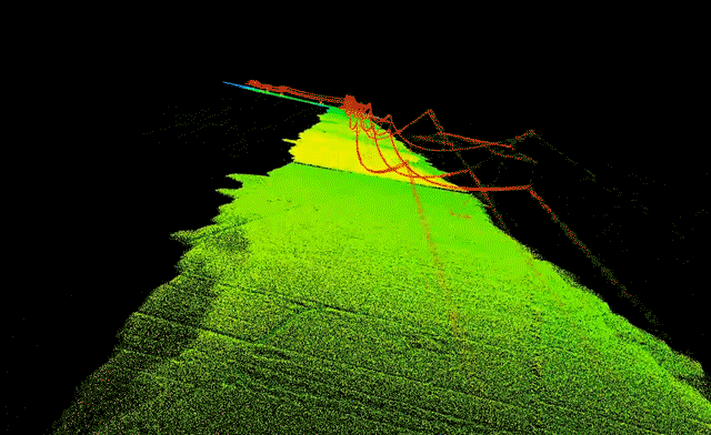
LiDAR returns survey-grade, georeferenced 3D—terrain, canopy, corridors, structures.
Outcome: one sortie yields thermal context + precise geometry, minimizing site moves and battery cycles.
Where the Combo Pays for Itself
Emergency & SAR: nighttime search, fire reconnaissance, disaster triage.
Energy & Linear Assets: thermal hotspot detection + LiDAR for clearances and encroachment change.
Engineering & Environmental: thermal anomalies (leaks, heat loss) + LiDAR for cut/fill, volumes, and grade.
Thermal Payload: The Specs That Actually Matter
Resolution & usable zoom dictate standoff distance and identification confidence.
Our payload options integrate 4K imaging, up to 240× hybrid zoom, and laser rangefinding to 3,000 m—vital for target confirmation and safer stand-off in inspections and public-safety work.
LiDAR Payload: Range, Density, Accuracy, Sync
Focus on range, point density at your planned altitude, and tight GNSS/IMU sync.
Clean boresight calibration is essential; wind-stable airframes protect point-cloud fidelity.
Our flight-control stack is engineered for stable dynamics in gusts, which preserves data quality upstream—before you ever open your processing software.
Airframe Advantages That Move the Needle
Dual-wing + multi-rotor with FOC (Field-Oriented Control) for smooth attitude control in wind.
Mission uptime features: quick assembly, rapid battery swaps, GNSS anomaly handling, and autonomous Return-to-Home.
Category signals: up to 2× endurance versus conventional VTOL architectures in comparable configurations.
Field Deployment: Pack, Click, Launch
Backpack portability, one-touch VTOL, autonomous cruise, and fast preflight checks cut your cost per dataset. That’s how teams hit SLAs on busy weeks and short weather windows.
Safety & Compliance
Specs only matter if your risk review says “go.” Our platform stack includes automatic RTH on link/battery events and CAAC Special Airworthiness Certification progress on designated models—practical signals for enterprise governance and insurers.
Who We Are
CHANG CHUN CHANG GUANG BO XIANG UAV Co., Ltd. (Boxiang) designs, builds, and supports intelligent UAVs. We operate an 8,000+ m² R&D and production facility with dedicated flight-testing airspace. Our engineering lineage traces to the UAV division of the Chinese Academy of Sciences (founded 2009) and was restructured into an innovation-driven company in 2021.
What Sets Boxiang Apart
Aerodynamics & Control: dual-wing + multi-rotor layout with FOC for stable flight in wind.
Operational Flow:one-click VTOL, quick assembly, autonomous cruise, fast battery changes.
Safety & Reliability: GNSS-event handling, RTH, robust comms architecture.
Field Proof: multi-industry deployments across civil and defense scenarios.
Buyer’s Guide: How to Evaluate a Fixed-Wing VTOL UAV for Sale
Prioritize what affects data quality, crew time, and ROI:
Endurance at your payload weight (not empty-airframe numbers).
Wind stability and station-holding.
Takeoff/landing footprint & site tolerance.
Thermal: sensor resolution, optical zoom, 3,000 m laser ranging for safe standoff.
LiDAR: range at altitude, point density, alignment & timing sync.
Safety stack: RTH, GNSS handling, failsafes.
Modularity: quick-release payloads; swap EO/IR, LiDAR, or RGB without rewiring.
Support: scenario-based training, warranty terms, parts availability, and engineering response time.
Endurance vs. Payload—The Real Trade-Off
Heavier payloads shorten flight time. Efficient aerodynamics, propulsion, and attitude control keep endurance viable while carrying work-grade sensors. Our category signals show up to 2× endurance and 2× payload capacity versus conventional VTOL classes in similar use.
Data Pipelines & Software
Your Thermal + LiDAR outputs should drop into existing stacks—point-cloud software, thermal analytics, and GIS. Our modular payload bay and quick-release mounts are designed for fast reconfiguration between EO/IR and LiDAR missions.
Mission Profiles That Benefit Most
Corridor mapping: powerlines, pipelines, rail, and coastlines.
Disaster mapping: minimal launch sites, blocked roads.
Large-area forestry & agriculture: fixed-wing cruise expands acreage per flight.
Payload Options (Thermal, Optical, LiDAR)
Our lineup integrates optical, infrared, and LiDAR payloads with 4K imaging, up to 240× hybrid zoom, and laser ranging to 3,000 m—ideal for long-standoff inspections and precise target confirmations in complex terrain.
Field-Proven Workflow: From Launch to Decision-Grade Maps
Plan: GCP strategy for LiDAR QA/QC; schedule thermal passes for maximum temperature contrast.
Acquire: one-click VTOL → climb → cruise; capture synchronized LiDAR + thermal streams.
Process: IMU/GNSS smoothing → boresight & strip alignment → thermal orthomosaic with radiometric calibration.
Fuse: overlay thermal anomalies on 3D geometry to pinpoint components and measure clearances.
Deliver: GIS-ready point clouds, DSM/DTM, contours, and thermal layers for maintenance systems.
Total Cost of Ownership & ROI
TCO isn’t just the purchase price. Count fewer site moves, shorter field days, less travel, and higher first-pass data confidence. Dual-payload sorties compress timelines and raise utilization in narrow weather windows. Certification milestones and documented safety features often accelerate approvals for regulated work.
Quick-Scan Checklist (Save this)
Endurance at your actual payload weight
Wind-stable platform with a documented safety stack
One-click launch and fast assembly for tight sites
Thermal resolution, optical zoom, and 3,000 m rangefinding
LiDAR range/density matched to your altitude & speed
Proven mission types: inspection, security, emergency, mapping, long-range
Training, warranty, and responsive support
FAQs (Buyer-Focused)
Q1. Can I switch between Thermal + LiDAR and other payloads without rewiring?
Yes. Our payload bay is modular and quick-release, built for multi-scenario swaps.
Q2. How does the platform handle wind and GNSS hiccups?
The control stack is tuned for strong-wind stability, with GNSS anomaly handling and automatic RTH integrated into the safety layer.
Q3. Which industries see the fastest ROI?
Power and pipeline inspection, public safety, and mapping—missions where long legs + quick launches + dual-payload data cut site moves and crew hours.
Q4. Are there signals of regulatory maturity?
We reference CAAC Special Airworthiness Certification progress for designated models—useful to enterprise risk committees and insurers.
Q5. What spec cues should I prioritize?
Endurance-at-payload, wind stability, safety features, payload specifics (4K/zoom/3,000 m ranging for EO/IR; range/density for LiDAR), and deployment speed.
Why Choose Boxiang for Thermal + LiDAR on Dual-Wing VTOL
Engineering depth: dual-wing + multi-rotor layout with FOC control for steady data in wind.
Operational polish: one-click VTOL, quick assembly, backpack portability, rapid battery swaps.
Payload breadth: optical/IR/LiDAR with 4K, 240× hybrid zoom, 3,000 m laser ranging.
Enterprise signals: R&D lineage to the Chinese Academy of Sciences, 8,000+ m² facility with test airspace, and measurable progress on certification.