
Fixed Wing UAV for Sale: A Practical Payload Guide for Dual Fixed-Wing VTOL
Why dual fixed-wing VTOL matters for modern payloads
Fixed-wing airframes cruise efficiently; multirotors launch anywhere. A dual fixed-wing VTOL platform merges both: runway-free deployment with airplane-like range. That combination is exactly what payloads need—stable speed, long dwell time, and mission endurance to finish work in a single sortie. It’s why teams mapping 200+ km corridors, monitoring coastlines overnight, or flying BVLOS keep choosing this class.
What we build at Boxiang UAV
CHANG CHUN CHANG GUANG BO XIANG UAV Co., Ltd. (Boxiang UAV) engineers dual-wing VTOL platforms for endurance, payload capacity, wind resilience, agile handling, and field portability. Our product and payload pages cover LiDAR, multispectral, and EO/IR options with documented long flight times and robust sensor support. Select models have been publicized with airworthiness approvals (e.g., CAAC for TW-series classes)—helping regulated operators accelerate compliance.
Payload types at a glance
LiDAR (mapping speed, point density, IMU coupling)
Choose LiDAR when you need bare-earth models through canopy, precise corridor geometry, or volumetrics. Quality hinges on the pairing of the laser to a survey-grade IMU/GNSS and an airframe that holds speed/altitude steady. Think in points/m², scan rate, beam divergence, returns per pulse, and look angles over target.
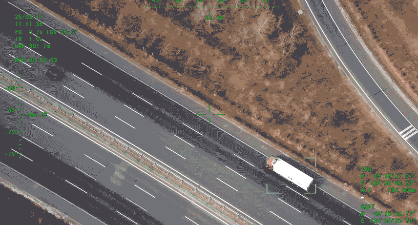
EO/IR (day/night ISR, stabilization, detection range)
Daylight EO plus thermal IR delivers 24/7 intelligence and inspection. A 2/3-axis stabilized gimbal cleans up turbulence for readable standoff footage. In ISR and security work, tracking, low-light sensitivity, thermal NETD, and metadata matter as much as raw resolution.
Multispectral (vegetation indices, radiometric workflow)
Multispectral imagers capture narrow bands (e.g., Blue, Green, Red, Red-edge, NIR) to assess plant stress and canopy vigor. Accuracy depends on radiometric calibration, consistent flight timing, and GSD aligned with crop spacing.
LiDAR on Fixed-Wing VTOL: What to Know
Dual fixed-wing VTOL gives LiDAR both area coverage and IMU stability. Pick sensors from compact mid-altitude units to survey-grade workhorses with multiple returns.
Buying checklist (quick reference)
Safety/class: Prefer Class 1 eye-safe for civil work.
Scan architecture: Rotating mirror vs. solid-state; look for uniform angular sampling.
Pulse & scan rate: More pulses can lift point density—if airspeed/altitude aren’t limiting.
Beam divergence: Narrow = edges & wires; wider can aid canopy penetration.
Returns per pulse: Key for vegetation and powerline corridors.
GNSS/IMU: Go survey-grade; keep boresight tight.
FOV & overlap: Ensure cross-track coverage to hit point-density targets at altitude.
Boresight & lever arms: Calibrate roll/pitch/yaw; measure sensor-to-antenna offsets precisely.
Power & thermal: Budget 20–60 W+ continuous draw; plan airflow and heat paths.
Data pipeline: SSD capacity, write speeds, and a robust QC workflow.
Accuracy tools: Even with excellent IMUs, GCPs tighten absolute accuracy. For long corridors, PPK and strip adjustment mitigate GNSS dropouts and deliver clean line-to-line fits.
EO/IR on Fixed-Wing VTOL: Specs That Matter
Use EO/IR for security, wildlife, border/coastal patrol, search-and-rescue, and critical-asset inspections. Launch from a clearing or ship deck, then cruise quietly on wing lift to extend station time.
Spec cheat-sheet
Gimbal: 2- or 3-axis with low residual jitter.
EO sensor: Larger sensor + smaller pixel pitch = more detail at range; 20–30× optical zoom is common for standoff.
Thermal:NETD ≤ 50 mK for subtle temperature deltas; choose lens FOV to match target distance.
Tracking & metadata:Object tracking, STANAG/KLV metadata, geo-pointing for analysts and responders.
Link reliability:Encrypted links, adaptive bitrate, and fallback paths; ISR is only as good as the downlink.
Policy & security: For public-safety or defense, plan encrypted C2/video, audited storage, and access controls from day one.
Multispectral on Fixed-Wing VTOL: Data Quality Basics
Multispectral shines in agriculture, forestry, and land-reclamation. Reproducibility is the trick: same local solar time, stable wind, and consistent calibration.
Spectral bands: Match NDVI, NDRE, SAVI and your crop phenology.
Radiometry: Panel shots before/after every sortie or a calibrated downwelling sensor—but be consistent.
GSD planning: Tie altitude to crop/plot scale; avoid aliasing in narrow rows.
SNR & exposure: Shutter speeds that freeze motion without starving signal.
Weather discipline: Broken clouds create reflectance swings; gusts blur imagery.
Indices & agronomy:NDVI for vigor; NDRE for dense/late canopy; SAVI where bare soil skews indices. Ground-truth with scouting or tissue tests.
Integration: How the Airframe Makes Sensors Better
Center of gravity: Keep CG in spec after mounting sensors and batteries.
Vibration isolation: Protect rolling-shutter cameras and LiDAR IMUs.
Power budget: Provide 12–48 V rails, account for warm-up peaks, and maintain airflow.
Comms planning: Size control/video/telemetry bandwidth with margin and redundancy.
Calibration: Run boresight on a high-contrast pattern or range; document lever-arm offsets to the GNSS antenna phase center and bake them into the trajectory solver.
Telemetry hygiene: Adaptive bitrates, FEC, and dual links (primary/backup) for BVLOS.
Boxiang UAV Advantages & Certifications
Founded on the UAV division of the Chinese Academy of Sciences (2009) and restructured as an innovation-driven enterprise in 2021, Boxiang UAV is recognized in Jilin Province as a “Specialized, Refined, Distinctive, and Innovative Enterprise” and serves as a provincial-level national economic mobilization center (background per user-provided company info). Our dual-wing VTOL lineup emphasizes:
Multi-hour endurance and heavy payload support
RTK-grade positioning and broad sensor compatibility
A payload ecosystem spanning LiDAR, EO/IR, and multispectral, plus customization for sector-specific tasks
Select models publicly noted for airworthiness progress (e.g., CAAC for TW-series classes)
Result: one airframe that fits multiple missions—and a shorter path through enterprise compliance and risk reviews.
Mission blueprints: pairing payloads with tasks
Corridor mapping (roads/rails/pipelines): LiDAR at altitude for consistent point density over terrain; add RGB for colorized point clouds. Dual-wing VTOL lets you launch beside the ROW and still cover 100+ km/day.
Powerline & telecom: LiDAR for sag/clearance; EO/IR for insulator cracks, hotspots. Fixed-wing lift helps in steady winds.
Coastal ISR & border patrol: EO/IR gimbals with long optical zoom and low-NETD thermal keep detection ranges workable at safe standoff.
Forestry & biodiversity: Multispectral for canopy stress; LiDAR for structure—combine for biomass models.
Data workflow: planning → acquisition → processing → QA/QC
Planning: Choose altitude for target GSD/point density; set overlap/line spacing. Book flight windows with stable light and low wind.
Acquisition: Warm sensors; capture calibration panel shots (multispectral); record boresight passes (LiDAR); verify live telemetry.
Processing: LiDAR—trajectory/PPK, boresight solve, strip adjustment, classification. Imagery—radiometric correction, orthomosaics, thermal analytics.
QA/QC: Check against checkpoints/surveyed features; review residuals; re-fly gaps promptly.
Budgeting & Total Cost of Ownership
Beyond hardware, budget for:
Spares & consumables: Props, batteries, skids, cables.
Service: Preventive maintenance; calibration cycles (IMUs, gimbals).
Training: Pilot currency, payload operation, post-processing.
Software: LiDAR/imagery processing, data management, secure sharing.
Compliance: Ops manuals, insurance, audits where required.
A reliable program tracks cycles, schedules calibrations, keeps a buffer of mission-critical spares, and ties warranty to documented maintenance—how uptime stays >95%.
Platform lineup & payload ecosystem
Because our platforms are designed around endurance, payload headroom, and wind-resilient aerodynamics, you can swap from LiDAR to EO/IR to multispectral without redesigning the aircraft. That “one airframe, many missions” approach reduces training time and inventory complexity.
FAQs
How do I choose between LiDAR and photogrammetry for corridors?
If vegetation or wires matter, LiDAR wins. For high-res color surface models in open terrain, photogrammetry is economical. Many teams fly both: LiDAR for geometry, RGB for texture.
What’s the single biggest LiDAR mistake on fixed-wing VTOL?
Skipping boresight and lever-arm measurement. Perfect flight lines won’t fix strip misalignments caused by a few milliradians or centimeters.
How do I size telemetry for EO/IR?
Start from your max zoom + frame rate. Add 30–50% headroom, enable adaptive bitrate, and plan a backup link for BVLOS.
Do I need radiometric panels for multispectral every sortie?
If you want comparable indices across weeks or fields, yes—either panel shots each flight or a properly mounted downwelling sensor. Document the method.
What approvals help enterprise deployments?
Industry-recognized airworthiness/conformity progress can shorten risk reviews and insurance underwriting. Our public materials reference such progress on specific models.