
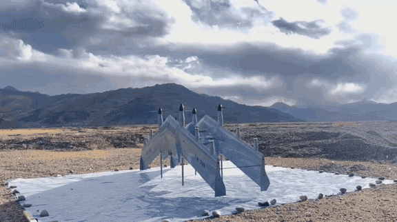
Airplane UAV, Reinvented: Dual Fixed-Wing VTOL for True Long-Range Missions
Most people hear “long-range” and picture a slick wing rolling down a runway. Modern missions don’t wait for pavement. A dual fixed-wing VTOL airplane UAV blends fixed-wing cruise efficiency with vertical takeoff and landing, so you can lift from a clearing, rooftop, or ship deck—and still cover hundreds of square kilometers on a single flight.
From Runways to Anywhere: How VTOL Changes Deployment Math
Launch location is often the constraint. With VTOL, crews stop searching for runways and stage directly at the mission site. The result: fewer logistics, shorter turn times, more sorties per day, and a lower cost per kilometer.
Why a Dual Fixed-Wing VTOL Airplane UAV Goes the Distance
A dual-wing planform distributes lift and increases control authority throughout the envelope—especially during gusts and transitions. Paired with full-vector control, the platform stays stable where multirotors burn power just to hold position. Add efficient cruise aerodynamics and precise, automated transitions, and you protect range when the weather gets real. In practice: long endurance, strong wind performance, and runway-free ops—which map to lower operational risk and higher mission success.
onverting Watts to Kilometers: The Endurance Equation
Endurance rests on three levers:
Cruise lift-to-drag: The dual fixed-wing layout trims induced drag in level flight, delivering more miles per watt than rotor-only craft on the same battery budget.
Transition efficiency: Short, predictable, automated transitions avoid long, wasteful attitude changes that eat range.
Hover discipline: Hover only when needed—launch, recovery, or brief observation—then settle into cruise where energy per kilometer drops dramatically.
Cruise Is Where Range Is Won
Clean wings and optimized prop loading are your savings account. In cruise, an airplane UAV leverages aerodynamics to turn stored energy into distance—not just lift.
Tight Transitions, Lower Penalties
Vector control and tuned prop loads keep transitions crisp and repeatable, preserving energy for the mission rather than maneuvers.
Hover Only When Necessary—And Make It Efficient
Vertical phases are brief and power-dense. Intelligent control minimizes hover time, then hands back to efficient cruise quickly.
Mission-Defining Specs (Highlights)
These specifications frame long-range mapping, patrol, delivery, and relay—without runway support.
Wingspan family: ~1.59–5.94 m
MTOW: ~7–200 kg
Endurance: up to ~8 hours (unladen)
Command & control links: ~50–100 km
Wind resistance: verified up to Beaufort 6–8 (phase-dependent)
Positioning: RTK-grade ≈ 1 cm + 1 ppm
Real-World Envelope
Operating temperature: ~−20 °C to +65 °C
Precipitation: light rain capable
Service ceiling: ~5,500 m
Phase-based wind limits: separate go/no-go thresholds for launch/landing vs. cruise
Fleet Families by Wingspan, MTOW, and Payload Window
Choose the airframe that fits the job: backpackable minis for quick sorties, mid-sizes for mapping and patrol, and heavy-lift variants for payloads in the tens of kilograms. Start small, scale programs, and keep training consistent across the family.
RTK-Level Positioning and Long-Haul Links
Redundant GNSS (GPS/GLONASS/BeiDou/Galileo) with RTK accuracy around 1 cm + 1 ppm keeps survey data tight. Long-haul 50–100 km links open reliable BVLOS corridors with sensible risk controls and standard procedures.
Payloads That Turn Range into Results
Range matters only if your sensors cash it in. Our ecosystem spans EO/IR, laser ranging, LiDAR, and full-frame/oblique imaging—each with quick-release mounts matched to the airframe family.
EO/IR Pods for Patrol and Inspection
Visible sensor: ~8.51 MP, 4K capture
Zoom: ~20× optical / ~240× hybrid
Thermal: 640×512 for night/obscurants
Laser ranging (tri-sensor options): up to ~3,000 m for precise geolocation
LiDAR for Engineering-Grade Point Clouds
Measuring range: up to ~1,500 m
Point frequency: up to ~500k pts/sec (five echoes)
Accuracy: centimeter-class, ideal for corridors, stockpiles, and as-builts
Long-range VTOL coverage reduces set-ups and increases corridor per sortie.
Oblique & Nadir Imaging for True-to-Life 3D
Systems: full-frame nadir and multi-lens oblique (including five-lens ~225 MP sets)
Benefit: faster 3D city models and documentation; swap optics in minutes to pivot from mapping to patrol the same day.
Safety, Stability, and Reliability by Design
Safety isn’t just a checklist—it’s architecture. The dual-wing layout and full-vector control stabilize the platform in turbulence. Automated safeguards manage link loss and low battery with return-to-home. GNSS anomaly handling and comprehensive self-checks reflect millions of cumulative flight hours and disciplined testing.
Health Monitoring, RTH, and GNSS Resilience
Continuous health monitoring flags small issues early; conservative RTH triggers and robust satellite-irregularity handling reduce pilot workload and keep risk low.
Field-Portable, Crew-Friendly Operations
Backpackable options, quick assembly/disassembly, one-button launch, autonomous cruise, and rapid battery swaps keep teams focused on outcomes—not on building an airfield.
Assembly, Battery Swaps, and Rapid Self-Checks
Self-checks complete in minutes with tool-light assembly—ideal for disaster response, narrow weather windows, and time-critical sorties.
Where Long Range Pays Off
Linear assets: power lines, pipelines—more corridor per sortie and better anomaly cadence.
Forestry & watershed patrol: wide-area coverage with day/night imaging.
Border & maritime awareness: endurance plus 4K/thermal and laser ranging turns “I think” into “I know.”
Disaster response & medical/supply lift: VTOL from improvised sites, long-leg comms relay, wide-area damage survey.
TCO: Cost per Kilometer and Fleet Utilization
Longer legs mean fewer aircraft-hours for the same area, cutting energy, crew hours, and vehicle time. Modular payloads amplify utilization across departments—so you can justify one scalable fleet instead of many single-purpose systems.
When Multirotors Lose the Range Game
Multirotors excel up close. But once missions stretch into tens of kilometers, hover-only craft spend too much energy on lift. A winged VTOL airplane UAV converts that energy into distance.
Why CHANG CHUN CHANG GUANG BO XIANG UAV Co., Ltd.
We are a leading high-tech UAV company spanning R&D, manufacturing, sales, and service—recognized in Jilin Province as a Specialized, Refined, Distinctive, and Innovative Enterprise and designated as a provincial-level national economic mobilization center. Our roots trace to the UAV Division of the Chinese Academy of Sciences (2009) and a 2021 restructuring into an innovation-driven enterprise—heritage that shows up in engineering depth and mission reliability.
CAS Roots, Provincial Recognition, Defense-Grade R&D
Institutional rigor plus civilian-defense experience yields mature processes, disciplined testing, and a scalable architecture—from backpackable units to heavy-lift variants.
A Smart Buying Checklist for Long-Range Programs
Define mission metrics first (area per sortie, minimum SNR at max link distance, acceptable launch/cruise winds).
Map to endurance, payload mass/power, and required optics/LiDAR specs.
Validate BVLOS pathways (procedures, detect-and-avoid, C2 links, human factors).
Standardize on quick-release payloads and common batteries.
Train for windy-day procedures and emergency RTH behaviors.
Certification, Training, and BVLOS Preparation
Align flight ops, maintenance, and data teams. Build playbooks for corridors, emergency launches, and link-loss drills. You get predictable sorties, repeatable data, and safer operations.
Conclusion
The future of range isn’t runway-bound. It’s dual fixed-wing VTOL—wing efficiency in cruise and rotor authority for launch and recovery. Pair that airframe with a mature payload stack and safety-first autonomy, and you have an airplane UAV built for real work across utilities, security, and emergency response—without compromising endurance or deployment freedom.
FAQs
1) How far can an airplane UAV in this class really go on one mission?
Endurance depends on payload and wind, but the family lists up to ~8 hours (unladen) with links of ~50–100 km. Planned with sensible reserves, that translates into serious area coverage.
2) Which payloads do teams adopt first?
Utilities and security programs often start with EO/IR (4K + thermal, ~20× optical / ~240× hybrid zoom) and add laser ranging for precise coordinates. Survey groups add LiDAR or full-frame/oblique cameras.
3) How does it handle wind?
Dual-wing layout plus full-vector control emphasizes stability. Wind limits are defined per phase (launch/landing vs. cruise) to guide clear go/no-go decisions.
4) Is it truly field-portable?
Yes. Backpackable models, quick assembly, one-button launch, and rapid self-checks support small teams at remote sites.
5) Where can I see compatible payload options?
See the payload series page for full specs on EO/IR, LiDAR, and imaging systems, including weight and aircraft compatibility charts.