
Industrial Drone Inspection for High-Risk and Remote Assets
Industrial drone inspection gives asset owners and field teams a practical way to examine long routes, difficult structures, and potentially unsafe locations before deploying people and access equipment.
Instead of relying only on ground patrols, climbing, scaffolding, cranes, or rope access, an inspection team can first deploy a UAV to collect visual images, thermal data, mapping information, LiDAR point clouds, or distance measurements.
The result is not simply an aerial photograph. A complete industrial drone inspection system combines the aircraft, payload, communication link, mission planning, data processing, and inspection workflow.
For power lines, pipelines, bridges, dams, mines, oil and gas facilities, forests, and emergency sites, this approach can help teams identify where closer inspection is needed and prepare the right people and equipment before entering the site.
What Is Industrial Drone Inspection?
Industrial drone inspection is the use of an unmanned aerial vehicle and mission-specific sensors to collect information about industrial assets, infrastructure, terrain, or operating environments.
Depending on the mission, the UAV may be used to:
record high-resolution visual images;
inspect components with an optical zoom camera;
identify thermal differences with an infrared sensor;
map terrain and infrastructure;
create orthophotos or 3D models;
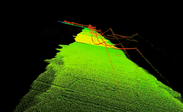
collect LiDAR point-cloud data;
measure the distance to a target;
observe inaccessible or potentially unsafe areas;
build repeatable inspection records over time.
The UAV does not replace engineers, maintenance teams, or qualified inspectors. Its role is to improve how inspection data is collected and help specialists decide where manual inspection, testing, or repair is required.
Where Industrial Drone Inspection Creates Value
Industrial sites present different inspection challenges. Some involve tall structures, while others involve long routes, unstable terrain, restricted access, or large areas that would take significant time to cover from the ground.
The aircraft and payload must be selected according to the asset. A platform suitable for a short bridge inspection may not be the best choice for a pipeline corridor extending across remote terrain.
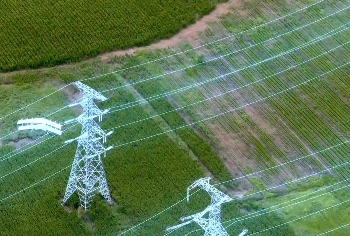
Power Line Inspection with Drones
Power transmission and distribution routes often cross mountains, forests, farmland, rivers, and areas with limited road access.
Manual inspection may require crews to travel between towers, climb structures, or work close to electrical equipment. Industrial drone inspection allows the team to collect preliminary data from the air before deciding which towers or components require closer attention.
A visible-light or optical zoom payload can be used to inspect:
tower structures;
conductors;
insulators;
fittings and connectors;
signs of physical damage;
foreign objects;
vegetation encroachment;
corridor conditions.
An infrared payload may provide additional information when the inspection objective includes abnormal thermal patterns in electrical components.
For a short group of towers, a multirotor aircraft may provide the necessary hovering and close-range observation. For long transmission corridors, a fixed-wing VTOL UAV can provide more efficient route coverage while retaining vertical takeoff and landing capability.
Pipeline Inspection and Corridor Patrol
Pipelines create a different operational challenge. The main issue is often the length of the route rather than the height of the asset.
A pipeline corridor may cross open land, mountains, river valleys, construction zones, farmland, or remote areas that are difficult to reach by vehicle. Even when the pipeline is underground, changes on the surface may still require attention.
A UAV patrol can help document:
erosion and ground movement;
exposed pipeline sections;
water damage;
changes near river crossings;
new construction;
vegetation changes;
unauthorized activity;
access-road conditions;
changes between scheduled inspections.
For these missions, aircraft endurance, communication range, payload weight, route planning, wind conditions, and emergency landing options must be considered together.
A small multirotor may be suitable for a facility or short pipeline section. A fixed-wing VTOL platform is usually more practical when the inspection requires continuous coverage over a longer corridor.
Bridge and Structural Inspection
Bridge inspection often requires access to surfaces that cannot be viewed clearly from the road or surrounding ground.
Traditional access may involve lifting equipment, lane closures, scaffolding, boats, or rope systems. A drone can first collect images of selected structural areas so engineers can identify where detailed manual inspection is necessary.
Typical targets may include:
bridge decks;
support structures;
beams;
cables;
joints;
visible corrosion;
surface deterioration;
surrounding slopes;
water-related changes near foundations.
Close inspection of a specific component may require stable hovering and controlled low-speed movement. Wide-area mapping of the bridge, approach roads, riverbanks, and nearby terrain may be better suited to a fixed-wing VTOL UAV.
For this reason, some bridge projects use more than one type of aircraft rather than expecting a single platform to perform every task.
Dam, Reservoir, and Water Infrastructure Inspection
Dams and water infrastructure combine large surface areas with difficult access, slopes, water, and changing environmental conditions.
Industrial UAV inspection can be used to document:
dam walls;
surrounding slopes;
reservoir shorelines;
spillways;
access routes;
visible surface changes;
erosion;
vegetation;
changes after storms or floods.
Mapping cameras and LiDAR payloads can help create repeatable terrain records. Engineers can compare data collected at different times to identify areas that require further investigation.
A UAV does not determine the structural safety of a dam by itself. It provides organized inspection data that supports engineering analysis and follow-up work.
Mining and Quarry Inspection
Mining environments change continuously because of excavation, blasting, material movement, weather, and daily operations.
Ground teams may need to work near slopes, haul roads, stockpiles, machinery, and active excavation areas. Deploying a UAV first can help the team understand current site conditions before entering selected zones.
Typical applications include:
slope observation;
stockpile measurement;
excavation monitoring;
haul-road inspection;
surface mapping;
drainage observation;
change detection;
documentation after heavy rain or ground movement.
Mapping cameras and LiDAR are often used when the project requires terrain models, volume calculations, point clouds, or repeatable site records.
Oil, Gas, and Energy Facility Inspection
Oil, gas, and energy sites may include elevated equipment, long pipe racks, storage tanks, perimeter areas, flare structures, and restricted operating zones.
Depending on the approved operating procedure and selected sensor, a UAV can help inspect:
tank exteriors;
pipe racks;
flare stacks;
facility roofs;
perimeter zones;
access roads;
visible surface conditions;
abnormal thermal patterns;
nearby terrain and drainage.
The platform must be selected carefully because these environments may involve specific safety requirements, restricted flight areas, electromagnetic conditions, hazardous zones, or company-specific operating rules.
The Industrial Drone Inspection Workflow
A successful inspection project begins before the aircraft takes off.
The mission should be designed around the information the engineering or maintenance team needs, rather than around the aircraft alone.
1. Define the Inspection Objective
The first step is to define what the team is trying to identify, measure, or document.
For example:
Is the objective to locate visible damage?
Does the team need thermal information?
Is a 3D model required?
Must the route be compared with an earlier inspection?
Does the operator need real-time video?
Is the mission intended to inspect individual components or an entire corridor?
A clear objective determines the required platform, payload, flight altitude, overlap, route, resolution, and data-processing method.
2. Evaluate the Site and Route
Before flight, the operator should review:
route length;
terrain;
elevation changes;
takeoff and landing area;
obstacles;
weather;
wind;
communication coverage;
emergency landing locations;
applicable airspace and operating requirements.
A technically capable UAV still needs an appropriate operating plan.
3. Select the UAV and Payload
The platform must have enough endurance and payload capacity for the mission while maintaining an appropriate operational reserve.
The payload should be selected according to the required inspection output.
A zoom camera is useful for observing distant components. An infrared sensor provides thermal information. A mapping camera supports orthophoto and 3D-model generation. LiDAR supports point-cloud and terrain-data collection.
Selecting the aircraft first and considering the payload later can lead to an unsuitable configuration. The sensor, aircraft, power supply, mounting system, communication link, and data workflow should be evaluated as one system.
4. Collect Consistent Inspection Data
During the mission, the operator should follow a repeatable collection method.
This may include:
consistent flight altitude;
controlled camera angle;
sufficient image overlap;
stable distance from the asset;
planned observation points;
accurate timestamps and position data;
standardized naming and storage procedures.
Consistent data becomes especially important when the site will be inspected repeatedly.
5. Review, Compare, and Prioritize
After the flight, engineers or inspection specialists review the collected material.
The purpose is not simply to gather a large number of images. The purpose is to turn those images and measurements into useful decisions.
The team may classify findings, compare them with previous records, mark areas for closer inspection, schedule maintenance, or deploy a manual team to a specific location.
What Data Can an Industrial Inspection Drone Collect?
The value of industrial drone inspection depends heavily on the selected payload.

Payload selection should be based on the required engineering output, not only on camera resolution or zoom ratio.
Multirotor vs Fixed-Wing vs Fixed-Wing VTOL Inspection Drones
No aircraft type is ideal for every industrial inspection.
A multirotor is often the better choice when the aircraft must remain close to a structure and hover around individual components.
A fixed-wing VTOL UAV becomes valuable when the mission combines limited launch space with long-distance or wide-area coverage.
Why Fixed-Wing VTOL UAVs Fit Long Inspection Routes
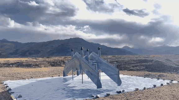
Fixed-wing VTOL platforms take off and land vertically, reducing dependence on a runway or launch system.
After takeoff, the aircraft transitions to efficient fixed-wing flight. This makes the platform suitable for missions where a conventional multirotor would require multiple battery changes or repeated launch locations.
Typical missions include:
power line corridors;
pipeline patrol;
forestry routes;
water conservancy inspection;
large mining areas;
coastline patrol;
emergency reconnaissance;
wide-area infrastructure mapping.
The main advantage is not simply longer flight time. It is the ability to combine practical field deployment with efficient route coverage.
How to Select an Industrial Drone Inspection System
Before choosing a system, the project team should evaluate the complete mission rather than comparing aircraft specifications in isolation.
Route Length and Coverage Area
A short facility inspection and a 100-kilometre corridor mission require different platforms, communication systems, operating procedures, and logistics.
Payload Weight and Power Requirements
Professional payloads add weight, aerodynamic drag, and electrical demand. Published endurance without a payload should not be treated as the expected endurance for a real inspection mission.
Ask for endurance information using a payload configuration similar to the planned operation.
Required Image Detail
The required ground sampling distance, zoom capability, stand-off distance, thermal resolution, or LiDAR density will affect the sensor and flight plan.
More resolution is not always better if it creates unnecessary data volume without improving the inspection decision.
Environmental Conditions
Consider:
wind;
temperature;
altitude;
light rain;
dust;
humidity;
terrain;
visibility;
electromagnetic conditions.
The system should be evaluated under conditions close to the intended operating environment.
Communication and Control Range
The communication system must support the route, terrain, real-time video requirements, and applicable operating rules.
Maximum communication distance should not be evaluated without considering line of sight, terrain, antenna configuration, interference, and regulatory restrictions.
Required Deliverables
Clarify whether the final output will be:
photographs;
video;
thermal records;
defect locations;
orthophotos;
3D models;
point clouds;
volume calculations;
change-detection reports;
real-time situational awareness.
The required deliverable determines the complete aircraft, payload, positioning, processing, and software configuration.
BOXIANG Industrial Drone Inspection Solutions
BOXIANG provides electric and hybrid fixed-wing VTOL platforms for industrial missions with different route lengths, payload requirements, and operating conditions.
The system can be configured with mission payloads such as:
visible-light and zoom cameras;
EO/IR gimbals;
laser rangefinders;
mapping cameras;
oblique cameras;
LiDAR;
multispectral sensors;
lighting equipment;
communication relay modules.
Ground control stations and automated drone-dock solutions can also be integrated according to the inspection workflow.
Example Inspection Configurations
The final configuration should be selected after reviewing the route, payload, environment, communication requirements, data output, and local operating conditions.
Information to Prepare Before Requesting a Solution
To receive a more suitable industrial drone inspection recommendation, prepare the following information:
type of asset;
route length or inspection area;
expected flight duration;
terrain and operating altitude;
typical wind and temperature;
required payload;
target observation distance;
required image or mapping output;
communication distance;
takeoff and landing conditions;
transport requirements;
local aviation or operating restrictions.
Providing this information allows the aircraft, payload, communication link, ground station, and supporting equipment to be evaluated together.
Build an Inspection System Around the Mission
Industrial drone inspection is not only about replacing manual access with an aircraft.
A useful inspection system must collect the right data, over the required distance, under real field conditions, and deliver information that engineers and maintenance teams can act on.
For close structural inspection, a multirotor may remain the most suitable option. For long corridors, remote sites, and wide-area infrastructure, a fixed-wing VTOL UAV can provide a more efficient balance between deployment flexibility, endurance, payload integration, and route coverage.
BOXIANG can provide platform and payload recommendations based on the asset, route, environment, and required inspection output.
Frequently Asked Questions
What is industrial drone inspection?
Industrial drone inspection uses UAVs and specialized payloads to collect visual, thermal, mapping, LiDAR, or ranging data from industrial assets and difficult operating environments.
What industries use drones for inspection?
Common applications include electric utilities, pipelines, oil and gas, bridges, dams, mining, construction, forestry, water conservancy, renewable energy, and emergency response.
Can drones replace human inspectors?
No. Drones collect information and improve access, but qualified specialists are still required to evaluate findings, perform detailed testing, make engineering decisions, and complete repairs.
What is the best drone for industrial inspection?
The best platform depends on the route, asset, sensor, required detail, weather, communication distance, and deliverable. Multirotors are useful for close hovering, while fixed-wing VTOL UAVs are often better for long corridors and wide-area missions.
Why use a fixed-wing VTOL UAV for inspection?
A fixed-wing VTOL UAV can take off vertically from a limited area and then transition to more efficient forward flight. This combination is useful for long-distance inspection routes without conventional runway access.
What payloads are used for industrial drone inspection?
Common payloads include visible-light cameras, optical zoom cameras, thermal sensors, EO/IR gimbals, mapping cameras, LiDAR, laser rangefinders, and multispectral sensors.
How should UAV endurance be evaluated?
Endurance should be evaluated using the intended payload, flight profile, wind, altitude, temperature, communication equipment, and operational reserve. Unladen endurance alone does not represent actual inspection performance.
Can the same UAV inspect power lines, pipelines, and mines?
A modular platform may support all three applications, but the payload, route, flight plan, processing workflow, and operating configuration will usually be different for each mission.